Ahualulco geodata
Ahualulco (Guerrero) is a populated place; located in Mexico in America/Mexico_City (GMT-6) time zone. With population of 592 people, there are 14508 cities with bigger population in this country. Compared to other cities in Mexico, 70.7% of cities are located further ↑North; 59.4% of cities are located further →East and 58.8% of cities have lower elevation than Ahualulco. Note1


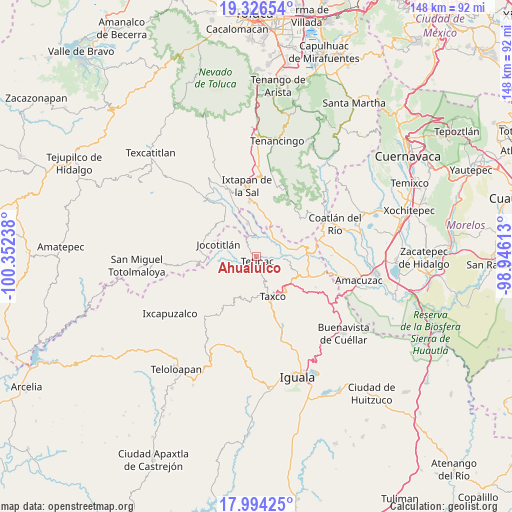
Ahualulco GPS coordinates[2]
18° 39' 42.12" North, 99° 38' 57.3" West
| Map corner | latitude | longitude |
|---|---|---|
| Upper-left | 19.32654°, | -100.35238° |
| Center: | 18.6617°, | -99.64925° |
| Lower-right: | 17.99425°, | -98.94613° |
| Map W x H: | 148.1×148.1 km | = 92×92mi |
| max Lat: | 32.7° ⇑70.7% North |
| Ahualulco: | 18.6617° |
| min Lat: | ⇓29.3% South 14.53588° |
| min Long | Ahualulco | max Long |
| -117.105° | -99.64925° | -86.73105° |
| W 40.6%⇐ | ⇒59.4% E |
Elevation
Elevation of Ahualulco is 1704 m = 5591 ft, and this is 450.3 m = 1477 ft above average elevation for this country.
| Max E: |
3497 m = 11473 ft | 41.2% |
| Ahualulco | 1704 m 5591 ft | |
| Avg. | 1253.7 m = 4113 ft | |
Min E: |
-1 m = -3 ft | 58.8% |
See also: Mexico elevation on elevation.city.
Geographical zone
Ahualulco is located in North Torrid zone (between Equator and Tropic of Cancer). Distance of this Northern Tropic circle is 530.9 km =329.9 mi to North.| Distance of | km | miles | from Ahualulco |
|---|---|---|---|
| North Pole | 7932.1 | 4928.8 | to North |
| Arctic Circle | 5326.2 | 3309.5 | to North |
| Tropic Cancer | 530.9 | 329.9 | to North |
| Equator | 2075 | 1289.3 | to South |


Nearby cities:
15 places around Ahualulco: (largest is in red/bold)
• Acuitlapan
13.1 km =8.1 mi,  120°
120°
• Cacalotenango
12.8 km =8 mi,  177°
177°
• Chontalcoatlán
8 km =5 mi,  95°
95°
• Colonia las Martelas
12.7 km =7.9 mi,  148°
148°
• El Mogote
9.2 km =5.7 mi,  77°
77°
• Huajojutla (El Azul)
12.2 km =7.6 mi,  138°
138°
• Jocotitlán
11.5 km =7.1 mi,  287°
287°
• La Concepción (La Concha)
12.6 km =7.8 mi,  338°
338°
• La Puerta de Santiago
11.9 km =7.4 mi,  12°
12°
• Pilcaya
9.9 km =6.2 mi, 344°
• San Andrés
4.3 km =2.7 mi,  111°
111°
• San Gregorio
6.8 km =4.2 mi, 121°
• Taxco de Alarcón
12.8 km =8 mi,  159°
159°
• Tenexcontitlán (El Ranchito)
2.1 km =1.3 mi,  310°
310°
• Tetipac
1.6 km =1 mi,  174°
174°
Sources, notices
• [Note1] Compared only with cities in Mexico existing in our database
• [Src1] Map data: © OpenStreetMap contributors (CC-BY-SA)
• [Src2] Other city data from geonames.org with taken over terms of usage.
• [Src3] Geographical zone / Annual Mean Temperature by Robert A. Rohde @ Wikipedia
