Sandía geodata
Sandía (Michoacán) is a populated place; located in Mexico in America/Mexico_City (GMT-6) time zone. With population of 591 people, there are 14530 cities with bigger population in this country. Compared to other cities in Mexico, 53.2% of cities are located further ↓South; 66.5% of cities are located further →East and 93.2% of cities have lower elevation than Sandía. Note1


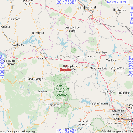
Sandía GPS coordinates[2]
19° 48' 55.008" North, 100° 12' 24.984" West
| Map corner | latitude | longitude |
|---|---|---|
| Upper-left | 20.47538°, | -100.91007° |
| Center: | 19.81528°, | -100.20694° |
| Lower-right: | 19.15242°, | -99.50382° |
| Map W x H: | 147.1×147.1 km | = 91.4×91.4mi |
| max Lat: | 32.7° ⇑46.8% North |
| Sandía: | 19.81528° |
| min Lat: | ⇓53.2% South 14.53588° |
| min Long | Sandía | max Long |
| -117.105° | -100.20694° | -86.73105° |
| W 33.5%⇐ | ⇒66.5% E |
Elevation
Elevation of Sandía is 2541 m = 8337 ft, and this is 1287.3 m = 4223 ft above average elevation for this country.
| Max E: |
3497 m = 11473 ft | 6.8% |
| Sandía | 2541 m 8337 ft | |
| Avg. | 1253.7 m = 4113 ft | |
Min E: |
-1 m = -3 ft | 93.2% |
See also: Mexico elevation on elevation.city.
Geographical zone
Sandía is located in North Torrid zone (between Equator and Tropic of Cancer). Distance of this Northern Tropic circle is 402.7 km =250.2 mi to North.| Distance of | km | miles | from Sandía |
|---|---|---|---|
| North Pole | 7803.8 | 4849.1 | to North |
| Arctic Circle | 5197.9 | 3229.8 | to North |
| Tropic Cancer | 402.7 | 250.2 | to North |
| Equator | 2203.3 | 1369.1 | to South |


Nearby cities:
15 places around Sandía: (largest is in red/bold)
• Barrio la Estrellita
8.3 km =5.2 mi,  91°
91°
• El Gigante
4.1 km =2.5 mi,  18°
18°
• El Oro de Hidalgo
8.1 km =5 mi,  99°
99°
• Estanzuela (La Hacienda)
5.3 km =3.3 mi,  150°
150°
• Guadalupe Victoria
7 km =4.3 mi,  233°
233°
• La Mesa
7.5 km =4.7 mi,  127°
127°
• Los Remedios
2 km =1.2 mi,  142°
142°
• Monte Alegre
1.5 km =0.9 mi,  194°
194°
• San Isidro
5.3 km =3.3 mi,  176°
176°
• San Juan Tlalpujahuilla (Tlalpujahuilla)
5.3 km =3.3 mi,  121°
121°
• San Miguel el Alto (El Puerto)
6.4 km =4 mi,  302°
302°
• San Pedro Tarímbaro
2.1 km =1.3 mi,  247°
247°
• Santa María de los Ángeles
3.3 km =2.1 mi,  166°
166°
• Tlalpujahua de Rayón
3.6 km =2.2 mi,  108°
108°
• Venta de Bravo
6.4 km =4 mi,  33°
33°
Sources, notices
• [Note1] Compared only with cities in Mexico existing in our database
• [Src1] Map data: © OpenStreetMap contributors (CC-BY-SA)
• [Src2] Other city data from geonames.org with taken over terms of usage.
• [Src3] Geographical zone / Annual Mean Temperature by Robert A. Rohde @ Wikipedia
