Monte Alegre geodata
Monte Alegre (Michoacán) is a populated place; located in Mexico in America/Mexico_City (GMT-6) time zone. With population of 579 people, there are 14804 cities with bigger population in this country. Compared to other cities in Mexico, 52.8% of cities are located further ↓South; 66.6% of cities are located further →East and 97.1% of cities have lower elevation than Monte Alegre. Note1


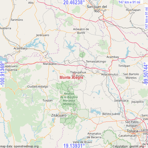
Monte Alegre GPS coordinates[2]
19° 48' 7.992" North, 100° 12' 38.016" West
| Map corner | latitude | longitude |
|---|---|---|
| Upper-left | 20.46238°, | -100.91369° |
| Center: | 19.80222°, | -100.21056° |
| Lower-right: | 19.13931°, | -99.50744° |
| Map W x H: | 147.1×147.1 km | = 91.4×91.4mi |
| max Lat: | 32.7° ⇑47.2% North |
| Monte Alegre: | 19.80222° |
| min Lat: | ⇓52.8% South 14.53588° |
| min Long | Monte Alegre | max Long |
| -117.105° | -100.21056° | -86.73105° |
| W 33.4%⇐ | ⇒66.6% E |
Elevation
Elevation of Monte Alegre is 2686 m = 8812 ft, and this is 1432.3 m = 4699 ft above average elevation for this country.
| Max E: |
3497 m = 11473 ft | 2.9% |
| Monte Alegre | 2686 m 8812 ft | |
| Avg. | 1253.7 m = 4113 ft | |
Min E: |
-1 m = -3 ft | 97.1% |
See also: Mexico elevation on elevation.city.
Geographical zone
Monte Alegre is located in North Torrid zone (between Equator and Tropic of Cancer). Distance of this Northern Tropic circle is 404.1 km =251.1 mi to North.| Distance of | km | miles | from Monte Alegre |
|---|---|---|---|
| North Pole | 7805.3 | 4850 | to North |
| Arctic Circle | 5199.4 | 3230.8 | to North |
| Tropic Cancer | 404.1 | 251.1 | to North |
| Equator | 2201.8 | 1368.1 | to South |


Nearby cities:
15 places around Monte Alegre: (largest is in red/bold)
• El Gigante
5.6 km =3.5 mi,  17°
17°
• Estanzuela (La Hacienda)
4.3 km =2.7 mi,  137°
137°
• Guadalupe Victoria
5.9 km =3.7 mi,  242°
242°
• La Mesa
7 km =4.3 mi,  116°
116°
• Los Remedios
1.6 km =1 mi,  95°
95°
• Los Reyes
7 km =4.3 mi,  224°
224°
• San Isidro
3.9 km =2.4 mi,  169°
169°
• San Juan Tlalpujahuilla (Tlalpujahuilla)
5 km =3.1 mi,  105°
105°
• San Miguel el Alto (El Puerto)
7 km =4.3 mi,  314°
314°
• San Pedro Tarímbaro
1.7 km =1.1 mi,  292°
292°
• San Rafael
8.1 km =5 mi,  189°
189°
• Sandía
1.5 km =0.9 mi,  14°
14°
• Santa María de los Ángeles
2.1 km =1.3 mi,  146°
146°
• Tlalpujahua de Rayón
3.8 km =2.4 mi,  84°
84°
• Venta de Bravo
7.9 km =4.9 mi,  29°
29°
Sources, notices
• [Note1] Compared only with cities in Mexico existing in our database
• [Src1] Map data: © OpenStreetMap contributors (CC-BY-SA)
• [Src2] Other city data from geonames.org with taken over terms of usage.
• [Src3] Geographical zone / Annual Mean Temperature by Robert A. Rohde @ Wikipedia
