Tetlaxco geodata
Tetlaxco (Veracruz) is a populated place; located in Mexico in America/Mexico_City (GMT-6) time zone. With population of 1,543 people, there are 5591 cities with bigger population in this country. Compared to other cities in Mexico, 64% of cities are located further ↑North; 74% of cities are located further ←West and 57% of cities have lower elevation than Tetlaxco. Note1


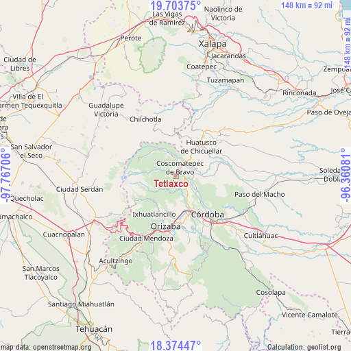
Tetlaxco GPS coordinates[2]
19° 2' 25.584" North, 97° 3' 50.148" West
| Map corner | latitude | longitude |
|---|---|---|
| Upper-left | 19.70375°, | -97.76706° |
| Center: | 19.04044°, | -97.06393° |
| Lower-right: | 18.37447°, | -96.36081° |
| Map W x H: | 147.8×147.8 km | = 91.8×91.8mi |
| max Lat: | 32.7° ⇑64% North |
| Tetlaxco: | 19.04044° |
| min Lat: | ⇓36% South 14.53588° |
| min Long | Tetlaxco | max Long |
| -117.105° | -97.06393° | -86.73105° |
| W 74%⇐ | ⇒26% E |
Elevation
Elevation of Tetlaxco is 1656 m = 5433 ft, and this is 402.3 m = 1320 ft above average elevation for this country.
| Max E: |
3497 m = 11473 ft | 43% |
| Tetlaxco | 1656 m 5433 ft | |
| Avg. | 1253.7 m = 4113 ft | |
Min E: |
-1 m = -3 ft | 57% |
See also: Mexico elevation on elevation.city.
Geographical zone
Tetlaxco is located in North Torrid zone (between Equator and Tropic of Cancer). Distance of this Northern Tropic circle is 488.8 km =303.7 mi to North.| Distance of | km | miles | from Tetlaxco |
|---|---|---|---|
| North Pole | 7890 | 4902.6 | to North |
| Arctic Circle | 5284.1 | 3283.4 | to North |
| Tropic Cancer | 488.8 | 303.7 | to North |
| Equator | 2117.1 | 1315.5 | to South |


Nearby cities:
15 places around Tetlaxco: (largest is in red/bold)
• Calaquioco
3.3 km =2.1 mi,  109°
109°
• Chocamán
4.5 km =2.8 mi,  133°
133°
• Coscomatepec de Bravo
4 km =2.5 mi,  26°
26°
• El Olvido (San Francisco)
5.4 km =3.4 mi,  256°
256°
• Gonzalo Vázquez Vela
2.2 km =1.4 mi, 34°
• Huilotla
2.9 km =1.8 mi,  238°
238°
• Ixtayuca (San Nicolás)
2.7 km =1.7 mi,  328°
328°
• Nicanor Espejo
2.9 km =1.8 mi,  35°
35°
• Rincón Pintor
5 km =3.1 mi,  173°
173°
• Tetla
5.9 km =3.7 mi,  176°
176°
• Tomatlán
5.8 km =3.6 mi,  100°
100°
• Xalatlaco
2.6 km =1.6 mi,  66°
66°
• Xocotla
4.8 km =3 mi,  234°
234°
• Xonotzintla
5.1 km =3.2 mi,  154°
154°
• Úrsulo Galván
5.4 km =3.4 mi,  21°
21°
Sources, notices
• [Note1] Compared only with cities in Mexico existing in our database
• [Src1] Map data: © OpenStreetMap contributors (CC-BY-SA)
• [Src2] Other city data from geonames.org with taken over terms of usage.
• [Src3] Geographical zone / Annual Mean Temperature by Robert A. Rohde @ Wikipedia
