Tihosuco geodata
Tihosuco (Quintana Roo) is a populated place; located in Mexico in America/Cancun (GMT-5) time zone. With population of 4,994 people, there are 1853 cities with bigger population in this country. Compared to other cities in Mexico, 61.3% of cities are located further ↓South; 99.4% of cities are located further ←West and 86.5% of cities have higher elevation than Tihosuco. Note1


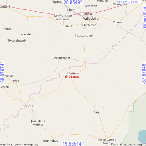
Tihosuco GPS coordinates[2]
20° 11' 47.112" North, 88° 22' 24.996" West
| Map corner | latitude | longitude |
|---|---|---|
| Upper-left | 20.8549°, | -89.07674° |
| Center: | 20.19642°, | -88.37361° |
| Lower-right: | 19.53514°, | -87.67049° |
| Map W x H: | 146.7×146.7 km | = 91.2×91.2mi |
| max Lat: | 32.7° ⇑38.7% North |
| Tihosuco: | 20.19642° |
| min Lat: | ⇓61.3% South 14.53588° |
| min Long | Tihosuco | max Long |
| -117.105° | -88.37361° | -86.73105° |
| W 99.4%⇐ | ⇒0.59999999999999% E |
Elevation
Elevation of Tihosuco is 36 m = 118 ft, and this is 1217.7 m = 3995 ft below average elevation for this country.
| Max E: |
3497 m = 11473 ft | 86.5% |
| Avg. | 1253.7 m = 4113 ft | |
| Tihosuco | 36 m = 118 ft | |
Min E: |
-1 m = -3 ft | 13.5% |
See also: Mexico elevation on elevation.city.
Geographical zone
Tihosuco is located in North Torrid zone (between Equator and Tropic of Cancer). Distance of this Northern Tropic circle is 360.3 km =223.9 mi to North.| Distance of | km | miles | from Tihosuco |
|---|---|---|---|
| North Pole | 7761.4 | 4822.7 | to North |
| Arctic Circle | 5155.5 | 3203.5 | to North |
| Tropic Cancer | 360.3 | 223.9 | to North |
| Equator | 2245.6 | 1395.4 | to South |


Nearby cities:
15 places around Tihosuco: (largest is in red/bold)
• Chan X-Cail
30.1 km =18.7 mi,  53°
53°
• Chikindzonot
19.3 km =12 mi,  322°
322°
• Dzitox
36.4 km =22.6 mi,  55°
55°
• Ekpedz
14.6 km =9.1 mi,  335°
335°
• Filomeno Mata
37.6 km =23.4 mi,  183°
183°
• Huay Max
23.4 km =14.5 mi,  222°
222°
• Ichmul
24.8 km =15.4 mi,  261°
261°
• Saban
24.9 km =15.5 mi, 223°
• Santa Rosa Segundo
26.9 km =16.7 mi,  154°
154°
• Tepich
13.2 km =8.2 mi,  67°
67°
• Tiholop
36.3 km =22.6 mi,  294°
294°
• Tuzik
38.4 km =23.9 mi,  144°
144°
• X Cabil
10 km =6.2 mi,  249°
249°
• Xcalak Dzonot
33.9 km =21.1 mi, 322°
• Zacalaca
27.6 km =17.1 mi,  237°
237°
Sources, notices
• [Note1] Compared only with cities in Mexico existing in our database
• [Src1] Map data: © OpenStreetMap contributors (CC-BY-SA)
• [Src2] Other city data from geonames.org with taken over terms of usage.
• [Src3] Geographical zone / Annual Mean Temperature by Robert A. Rohde @ Wikipedia
