Ekpedz geodata
Ekpedz (Yucatán) is a populated place; located in Mexico in America/Merida (GMT-6) time zone. With population of 1,374 people, there are 6315 cities with bigger population in this country. Compared to other cities in Mexico, 63.9% of cities are located further ↓South; 99.3% of cities are located further ←West and 88.6% of cities have higher elevation than Ekpedz. Note1


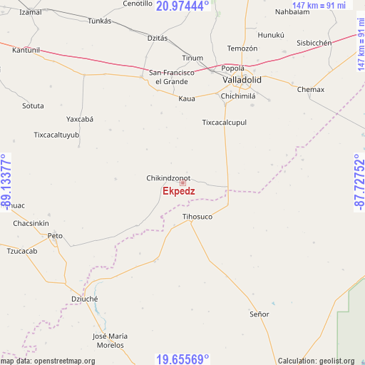
Ekpedz GPS coordinates[2]
20° 18' 59.292" North, 88° 25' 50.304" West
| Map corner | latitude | longitude |
|---|---|---|
| Upper-left | 20.97444°, | -89.13377° |
| Center: | 20.31647°, | -88.43064° |
| Lower-right: | 19.65569°, | -87.72752° |
| Map W x H: | 146.6×146.6 km | = 91.1×91.1mi |
| max Lat: | 32.7° ⇑36.1% North |
| Ekpedz: | 20.31647° |
| min Lat: | ⇓63.9% South 14.53588° |
| min Long | Ekpedz | max Long |
| -117.105° | -88.43064° | -86.73105° |
| W 99.3%⇐ | ⇒0.7% E |
Elevation
Elevation of Ekpedz is 28 m = 92 ft, and this is 1225.7 m = 4021 ft below average elevation for this country.
| Max E: |
3497 m = 11473 ft | 88.6% |
| Avg. | 1253.7 m = 4113 ft | |
| Ekpedz | 28 m = 92 ft | |
Min E: |
-1 m = -3 ft | 11.4% |
See also: Mexico elevation on elevation.city.
Geographical zone
Ekpedz is located in North Torrid zone (between Equator and Tropic of Cancer). Distance of this Northern Tropic circle is 346.9 km =215.6 mi to North.| Distance of | km | miles | from Ekpedz |
|---|---|---|---|
| North Pole | 7748.1 | 4814.4 | to North |
| Arctic Circle | 5142.2 | 3195.2 | to North |
| Tropic Cancer | 346.9 | 215.6 | to North |
| Equator | 2259 | 1403.7 | to South |


Nearby cities:
15 places around Ekpedz: (largest is in red/bold)
• Chan X-Cail
30.5 km =19 mi,  81°
81°
• Chikindzonot
6.1 km =3.8 mi,  288°
288°
• Huay Max
32.1 km =19.9 mi,  198°
198°
• Ichmul
25.2 km =15.7 mi,  227°
227°
• Kaua
34 km =21.1 mi,  2°
2°
• Saban
33.3 km =20.7 mi, 199°
• Tepich
19.9 km =12.4 mi,  114°
114°
• Ticimul
33.7 km =20.9 mi,  337°
337°
• Tiholop
27.1 km =16.8 mi,  273°
273°
• Tihosuco
14.6 km =9.1 mi,  155°
155°
• Tixcacalcupul
29.6 km =18.4 mi,  34°
34°
• X Cabil
17.2 km =10.7 mi,  191°
191°
• Xcalak Dzonot
19.9 km =12.4 mi,  313°
313°
• Xcopteil
27 km =16.8 mi,  324°
324°
• Zacalaca
33.1 km =20.6 mi,  211°
211°
Sources, notices
• [Note1] Compared only with cities in Mexico existing in our database
• [Src1] Map data: © OpenStreetMap contributors (CC-BY-SA)
• [Src2] Other city data from geonames.org with taken over terms of usage.
• [Src3] Geographical zone / Annual Mean Temperature by Robert A. Rohde @ Wikipedia
