Aguapinole (Cuapinole) geodata
Aguapinole (Cuapinole) (Veracruz) is a populated place; located in Mexico in America/Mexico_City (GMT-6) time zone. With population of 569 people, there are 15027 cities with bigger population in this country. Compared to other cities in Mexico, 79% of cities are located further ↑North; 84.2% of cities are located further ←West and 84.7% of cities have higher elevation than Aguapinole (Cuapinole). Note1


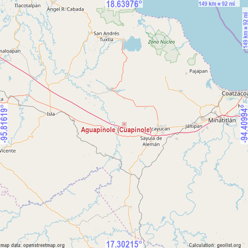
Aguapinole (Cuapinole) GPS coordinates[2]
17° 58' 19.992" North, 95° 6' 47.016" West
| Map corner | latitude | longitude |
|---|---|---|
| Upper-left | 18.63976°, | -95.81619° |
| Center: | 17.97222°, | -95.11306° |
| Lower-right: | 17.30215°, | -94.40994° |
| Map W x H: | 148.7×148.7 km | = 92.4×92.4mi |
| max Lat: | 32.7° ⇑79% North |
| Aguapinole (Cuapinole): | 17.97222° |
| min Lat: | ⇓21% South 14.53588° |
| min Long | Aguapinole (Cua | max Long |
| -117.105° | -95.11306° | -86.73105° |
| W 84.2%⇐ | ⇒15.8% E |
Elevation
Elevation of Aguapinole (Cuapinole) is 46 m = 151 ft, and this is 1207.7 m = 3962 ft below average elevation for this country.
| Max E: |
3497 m = 11473 ft | 84.7% |
| Avg. | 1253.7 m = 4113 ft | |
| Aguapinole (Cuapinole) | 46 m = 151 ft | |
Min E: |
-1 m = -3 ft | 15.3% |
See also: Mexico elevation on elevation.city.
Geographical zone
Aguapinole (Cuapinole) is located in North Torrid zone (between Equator and Tropic of Cancer). Distance of this Northern Tropic circle is 607.6 km =377.5 mi to North.| Distance of | km | miles | from Aguapinole (Cuapinole) |
|---|---|---|---|
| North Pole | 8008.7 | 4976.4 | to North |
| Arctic Circle | 5402.9 | 3357.2 | to North |
| Tropic Cancer | 607.6 | 377.5 | to North |
| Equator | 1998.3 | 1241.7 | to South |


Nearby cities:
15 places around Aguapinole (Cuapinole): (largest is in red/bold)
• Casas Viejas
15.4 km =9.6 mi,  276°
276°
• Chapopoapan
6.3 km =3.9 mi,  152°
152°
• Congregación Hidalgo
15.6 km =9.7 mi,  104°
104°
• Corral Nuevo
15.8 km =9.8 mi,  359°
359°
• Cruz del Milagro
12.9 km =8 mi,  123°
123°
• Dehesa
12.6 km =7.8 mi,  105°
105°
• Esperanza Malota
8.3 km =5.2 mi,  54°
54°
• La Cerquilla
9.4 km =5.8 mi,  139°
139°
• La Lima
7.1 km =4.4 mi,  224°
224°
• Loma de Hujuapan
11.5 km =7.1 mi,  292°
292°
• Nuevo Poblado el Hato
15.8 km =9.8 mi, 104°
• Quiamoloapan
15.9 km =9.9 mi, 51°
• Rancho Nuevo
7.6 km =4.7 mi, 152°
• San Juan Evangelista
10 km =6.2 mi,  196°
196°
• Vista Hermosa
7.7 km =4.8 mi,  134°
134°
Sources, notices
• [Note1] Compared only with cities in Mexico existing in our database
• [Src1] Map data: © OpenStreetMap contributors (CC-BY-SA)
• [Src2] Other city data from geonames.org with taken over terms of usage.
• [Src3] Geographical zone / Annual Mean Temperature by Robert A. Rohde @ Wikipedia
