Chojchow geodata
Chojchow (Chiapas) is a populated place; located in Mexico in America/Mexico_City (GMT-6) time zone. With population of 555 people, there are 15371 cities with bigger population in this country. Compared to other cities in Mexico, 90.2% of cities are located further ↑North; 93% of cities are located further ←West and 60.2% of cities have higher elevation than Chojchow. Note1


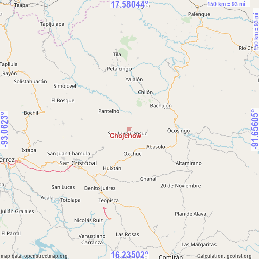
Chojchow GPS coordinates[2]
16° 54' 32.148" North, 92° 21' 33.012" West
| Map corner | latitude | longitude |
|---|---|---|
| Upper-left | 17.58044°, | -93.0623° |
| Center: | 16.90893°, | -92.35917° |
| Lower-right: | 16.23502°, | -91.65605° |
| Map W x H: | 149.6×149.6 km | = 93×93mi |
| max Lat: | 32.7° ⇑90.2% North |
| Chojchow: | 16.90893° |
| min Lat: | ⇓9.8% South 14.53588° |
| min Long | Chojchow | max Long |
| -117.105° | -92.35917° | -86.73105° |
| W 93%⇐ | ⇒7% E |
Elevation
Elevation of Chojchow is 987 m = 3238 ft, and this is 266.7 m = 875 ft below average elevation for this country.
| Max E: |
3497 m = 11473 ft | 60.2% |
| Avg. | 1253.7 m = 4113 ft | |
| Chojchow | 987 m = 3238 ft | |
Min E: |
-1 m = -3 ft | 39.8% |
See also: Mexico elevation on elevation.city.
Geographical zone
Chojchow is located in North Torrid zone (between Equator and Tropic of Cancer). Distance of this Northern Tropic circle is 725.8 km =451 mi to North.| Distance of | km | miles | from Chojchow |
|---|---|---|---|
| North Pole | 8127 | 5049.9 | to North |
| Arctic Circle | 5521.1 | 3430.7 | to North |
| Tropic Cancer | 725.8 | 451 | to North |
| Equator | 1880.1 | 1168.2 | to South |


Nearby cities:
15 places around Chojchow: (largest is in red/bold)
• Baquelchán
8.7 km =5.4 mi,  6°
6°
• Chacté
3.4 km =2.1 mi,  16°
16°
• Chiloljá
7.5 km =4.7 mi,  249°
249°
• Cruztón
7.6 km =4.7 mi,  162°
162°
• El Pozo
5.7 km =3.5 mi,  282°
282°
• El Tzay
7.1 km =4.4 mi,  135°
135°
• La Frontera
8.1 km =5 mi,  212°
212°
• La Frontera Uno
8.3 km =5.2 mi,  72°
72°
• La Palma Uno
7.5 km =4.7 mi,  350°
350°
• Oniltic
7.3 km =4.5 mi,  335°
335°
• San Juan Cancuc
2.1 km =1.3 mi, 212°
• Tzametal
7.4 km =4.6 mi,  237°
237°
• Tzuluwitz
5 km =3.1 mi, 243°
• Tzunjok
5.2 km =3.2 mi,  325°
325°
• Tzunún
7.9 km =4.9 mi,  191°
191°
Sources, notices
• [Note1] Compared only with cities in Mexico existing in our database
• [Src1] Map data: © OpenStreetMap contributors (CC-BY-SA)
• [Src2] Other city data from geonames.org with taken over terms of usage.
• [Src3] Geographical zone / Annual Mean Temperature by Robert A. Rohde @ Wikipedia
