Oxolotán geodata
Oxolotán (Tabasco) is a populated place; located in Mexico in America/Mexico_City (GMT-6) time zone. With population of 1,886 people, there are 4612 cities with bigger population in this country. Compared to other cities in Mexico, 84.4% of cities are located further ↑North; 90.1% of cities are located further ←West and 82.8% of cities have higher elevation than Oxolotán. Note1


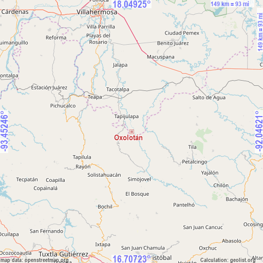
Oxolotán GPS coordinates[2]
17° 22' 46.092" North, 92° 44' 57.588" West
| Map corner | latitude | longitude |
|---|---|---|
| Upper-left | 18.04925°, | -93.45246° |
| Center: | 17.37947°, | -92.74933° |
| Lower-right: | 16.70723°, | -92.04621° |
| Map W x H: | 149.2×149.2 km | = 92.7×92.7mi |
| max Lat: | 32.7° ⇑84.4% North |
| Oxolotán: | 17.37947° |
| min Lat: | ⇓15.6% South 14.53588° |
| min Long | Oxolotán | max Long |
| -117.105° | -92.74933° | -86.73105° |
| W 90.1%⇐ | ⇒9.9% E |
Elevation
Elevation of Oxolotán is 62 m = 203 ft, and this is 1191.7 m = 3910 ft below average elevation for this country.
| Max E: |
3497 m = 11473 ft | 82.8% |
| Avg. | 1253.7 m = 4113 ft | |
| Oxolotán | 62 m = 203 ft | |
Min E: |
-1 m = -3 ft | 17.2% |
See also: Mexico elevation on elevation.city.
Geographical zone
Oxolotán is located in North Torrid zone (between Equator and Tropic of Cancer). Distance of this Northern Tropic circle is 673.5 km =418.5 mi to North.| Distance of | km | miles | from Oxolotán |
|---|---|---|---|
| North Pole | 8074.6 | 5017.3 | to North |
| Arctic Circle | 5468.8 | 3398.2 | to North |
| Tropic Cancer | 673.5 | 418.5 | to North |
| Equator | 1932.4 | 1200.7 | to South |


Nearby cities:
15 places around Oxolotán: (largest is in red/bold)
• Amatán
7.4 km =4.6 mi,  265°
265°
• Campamento el Mirador
8.2 km =5.1 mi,  113°
113°
• Cristóbal Colón
10.3 km =6.4 mi, 105°
• Cuauhtémoc Barreal
6 km =3.7 mi,  27°
27°
• Cuitláhuac
3.2 km =2 mi,  141°
141°
• El Bebedero
10.9 km =6.8 mi,  79°
79°
• Huanal
8.7 km =5.4 mi,  161°
161°
• Jesús Carranza
10.7 km =6.6 mi,  70°
70°
• La Esperanza
9.1 km =5.7 mi,  216°
216°
• Libertad
5 km =3.1 mi,  46°
46°
• Puxcatán
10.3 km =6.4 mi,  39°
39°
• Raya Zaragoza
7.4 km =4.6 mi, 66°
• Sombra Carrizal
9.1 km =5.7 mi,  178°
178°
• Tapijulapa
9.7 km =6 mi,  341°
341°
• Villa Luz
11.5 km =7.1 mi, 163°
Sources, notices
• [Note1] Compared only with cities in Mexico existing in our database
• [Src1] Map data: © OpenStreetMap contributors (CC-BY-SA)
• [Src2] Other city data from geonames.org with taken over terms of usage.
• [Src3] Geographical zone / Annual Mean Temperature by Robert A. Rohde @ Wikipedia
