Tecuanapam geodata
Tecuanapam (Oaxaca) is a populated place; located in Mexico in America/Mexico_City (GMT-6) time zone. With population of 540 people, there are 15727 cities with bigger population in this country. Compared to other cities in Mexico, 76.7% of cities are located further ↑North; 75.4% of cities are located further ←West and 68.1% of cities have lower elevation than Tecuanapam. Note1


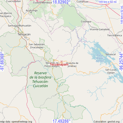
Tecuanapam GPS coordinates[2]
18° 9' 43.992" North, 96° 57' 38.016" West
| Map corner | latitude | longitude |
|---|---|---|
| Upper-left | 18.82902°, | -97.66369° |
| Center: | 18.16222°, | -96.96056° |
| Lower-right: | 17.49286°, | -96.25744° |
| Map W x H: | 148.6×148.6 km | = 92.3×92.3mi |
| max Lat: | 32.7° ⇑76.7% North |
| Tecuanapam: | 18.16222° |
| min Lat: | ⇓23.3% South 14.53588° |
| min Long | Tecuanapam | max Long |
| -117.105° | -96.96056° | -86.73105° |
| W 75.4%⇐ | ⇒24.6% E |
Elevation
Elevation of Tecuanapam is 1892 m = 6207 ft, and this is 638.3 m = 2094 ft above average elevation for this country.
| Max E: |
3497 m = 11473 ft | 31.9% |
| Tecuanapam | 1892 m 6207 ft | |
| Avg. | 1253.7 m = 4113 ft | |
Min E: |
-1 m = -3 ft | 68.1% |
See also: Mexico elevation on elevation.city.
Geographical zone
Tecuanapam is located in North Torrid zone (between Equator and Tropic of Cancer). Distance of this Northern Tropic circle is 586.5 km =364.4 mi to North.| Distance of | km | miles | from Tecuanapam |
|---|---|---|---|
| North Pole | 7987.6 | 4963.3 | to North |
| Arctic Circle | 5381.7 | 3344 | to North |
| Tropic Cancer | 586.5 | 364.4 | to North |
| Equator | 2019.4 | 1254.8 | to South |


Nearby cities:
15 places around Tecuanapam: (largest is in red/bold)
• El Duraznillo
6.1 km =3.8 mi,  203°
203°
• Huehuetlán Segunda Sección
4 km =2.5 mi,  26°
26°
• Los Frailes
6.7 km =4.2 mi,  169°
169°
• San Francisco Huehuetlán
4.1 km =2.5 mi,  18°
18°
• San Isidro Zoquiápam
8.1 km =5 mi,  153°
153°
• San Jerónimo Tecóatl
5.1 km =3.2 mi,  84°
84°
• San Juan Cuautla
9.1 km =5.7 mi,  2°
2°
• San Lorenzo Cuaunecuiltitla
7 km =4.3 mi,  45°
45°
• San Lucas Zoquiápam
6.5 km =4 mi,  115°
115°
• San Pedro Ocopetatillo
5.8 km =3.6 mi,  62°
62°
• Santa Cruz Acatepec
9 km =5.6 mi,  88°
88°
• Santa María Teopoxco
0.8 km =0.5 mi, 51°
• Santiago Texcalcingo
5.2 km =3.2 mi,  350°
350°
• Tepantitlán
5.5 km =3.4 mi,  332°
332°
• Villa Nueva
2.8 km =1.7 mi,  310°
310°
Sources, notices
• [Note1] Compared only with cities in Mexico existing in our database
• [Src1] Map data: © OpenStreetMap contributors (CC-BY-SA)
• [Src2] Other city data from geonames.org with taken over terms of usage.
• [Src3] Geographical zone / Annual Mean Temperature by Robert A. Rohde @ Wikipedia
