Las Magdalenas geodata
Las Magdalenas (San Luis Potosí) is a populated place; located in Mexico in America/Mexico_City (GMT-6) time zone. With population of 543 people, there are 15651 cities with bigger population in this country. Compared to other cities in Mexico, 83.2% of cities are located further ↓South; 63.4% of cities are located further →East and 60.2% of cities have higher elevation than Las Magdalenas. Note1


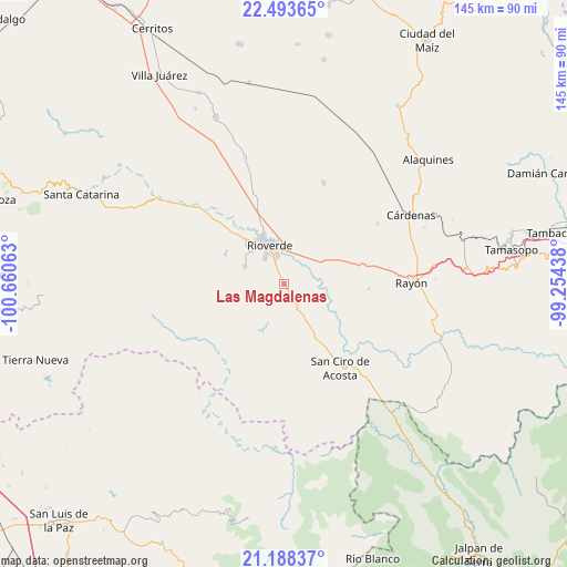
Las Magdalenas GPS coordinates[2]
21° 50' 33" North, 99° 57' 27" West
| Map corner | latitude | longitude |
|---|---|---|
| Upper-left | 22.49365°, | -100.66063° |
| Center: | 21.8425°, | -99.9575° |
| Lower-right: | 21.18837°, | -99.25438° |
| Map W x H: | 145.1×145.1 km | = 90.2×90.2mi |
| max Lat: | 32.7° ⇑16.8% North |
| Las Magdalenas: | 21.8425° |
| min Lat: | ⇓83.2% South 14.53588° |
| min Long | Las Magdalenas | max Long |
| -117.105° | -99.9575° | -86.73105° |
| W 36.6%⇐ | ⇒63.4% E |
Elevation
Elevation of Las Magdalenas is 988 m = 3241 ft, and this is 265.7 m = 872 ft below average elevation for this country.
| Max E: |
3497 m = 11473 ft | 60.2% |
| Avg. | 1253.7 m = 4113 ft | |
| Las Magdalenas | 988 m = 3241 ft | |
Min E: |
-1 m = -3 ft | 39.8% |
See also: Mexico elevation on elevation.city.
Geographical zone
Las Magdalenas is located in North Torrid zone (between Equator and Tropic of Cancer). Distance of this Northern Tropic circle is 177.3 km =110.2 mi to North.| Distance of | km | miles | from Las Magdalenas |
|---|---|---|---|
| North Pole | 7578.4 | 4709 | to North |
| Arctic Circle | 4972.5 | 3089.8 | to North |
| Tropic Cancer | 177.3 | 110.2 | to North |
| Equator | 2428.7 | 1509.1 | to South |


Nearby cities:
15 places around Las Magdalenas: (largest is in red/bold)
• Ciudad Fernández
12.2 km =7.6 mi,  332°
332°
• El Capulín
8.4 km =5.2 mi,  258°
258°
• El Jabalí
10.9 km =6.8 mi,  295°
295°
• El Pescadito
14.5 km =9 mi,  284°
284°
• El Zapote
15.3 km =9.5 mi,  203°
203°
• Ildefonso Turrubiartes (La Boquilla)
13.1 km =8.1 mi,  44°
44°
• La Loma
15.9 km =9.9 mi,  292°
292°
• Las Adjuntas
16.6 km =10.3 mi,  322°
322°
• Miguel Hidalgo
7.7 km =4.8 mi,  47°
47°
• Ojo de Agua Seco
11.6 km =7.2 mi,  274°
274°
• Plazuela
5.6 km =3.5 mi,  150°
150°
• Puerto de Martínez
16.5 km =10.3 mi, 151°
• Rioverde
10.6 km =6.6 mi,  338°
338°
• San Diego
17 km =10.6 mi, 299°
• San José del Tapanco
9.4 km =5.8 mi, 147°
Sources, notices
• [Note1] Compared only with cities in Mexico existing in our database
• [Src1] Map data: © OpenStreetMap contributors (CC-BY-SA)
• [Src2] Other city data from geonames.org with taken over terms of usage.
• [Src3] Geographical zone / Annual Mean Temperature by Robert A. Rohde @ Wikipedia
