Miguel Hidalgo geodata
Miguel Hidalgo (San Luis Potosí) is a populated place; located in Mexico in America/Mexico_City (GMT-6) time zone. With population of 799 people, there are 10920 cities with bigger population in this country. Compared to other cities in Mexico, 83.5% of cities are located further ↓South; 62.6% of cities are located further →East and 60.5% of cities have higher elevation than Miguel Hidalgo. Note1


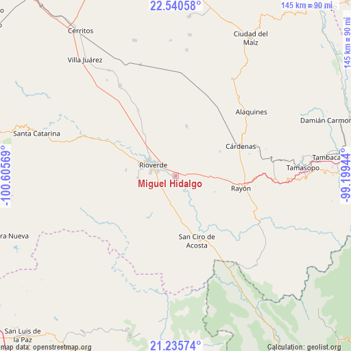
Miguel Hidalgo GPS coordinates[2]
21° 53' 22.74" North, 99° 54' 9.216" West
| Map corner | latitude | longitude |
|---|---|---|
| Upper-left | 22.54058°, | -100.60569° |
| Center: | 21.88965°, | -99.90256° |
| Lower-right: | 21.23574°, | -99.19944° |
| Map W x H: | 145.1×145.1 km | = 90.2×90.2mi |
| max Lat: | 32.7° ⇑16.5% North |
| Miguel Hidalgo: | 21.88965° |
| min Lat: | ⇓83.5% South 14.53588° |
| min Long | Miguel Hidalgo | max Long |
| -117.105° | -99.90256° | -86.73105° |
| W 37.4%⇐ | ⇒62.6% E |
Elevation
Elevation of Miguel Hidalgo is 972 m = 3189 ft, and this is 281.7 m = 924 ft below average elevation for this country.
| Max E: |
3497 m = 11473 ft | 60.5% |
| Avg. | 1253.7 m = 4113 ft | |
| Miguel Hidalgo | 972 m = 3189 ft | |
Min E: |
-1 m = -3 ft | 39.5% |
See also: Mexico elevation on elevation.city.
Geographical zone
Miguel Hidalgo is located in North Torrid zone (between Equator and Tropic of Cancer). Distance of this Northern Tropic circle is 172 km =106.9 mi to North.| Distance of | km | miles | from Miguel Hidalgo |
|---|---|---|---|
| North Pole | 7573.2 | 4705.8 | to North |
| Arctic Circle | 4967.3 | 3086.5 | to North |
| Tropic Cancer | 172 | 106.9 | to North |
| Equator | 2433.9 | 1512.4 | to South |


Nearby cities:
15 places around Miguel Hidalgo: (largest is in red/bold)
• Barrio de Guadalupe
17.7 km =11 mi,  303°
303°
• Cerrito de la Cruz
19.6 km =12.2 mi,  89°
89°
• Ciudad Fernández
12.6 km =7.8 mi, 296°
• Colonia Veinte de Noviembre
18.2 km =11.3 mi, 303°
• El Capulín
15.5 km =9.6 mi,  243°
243°
• El Jabalí
15.5 km =9.6 mi,  267°
267°
• Ildefonso Turrubiartes (La Boquilla)
5.4 km =3.4 mi,  40°
40°
• Las Adjuntas
17.7 km =11 mi, 296°
• Las Magdalenas
7.7 km =4.8 mi,  227°
227°
• Ojo de Agua Seco
17.8 km =11.1 mi,  256°
256°
• Plazuela
10.5 km =6.5 mi,  196°
196°
• Rioverde
10.6 km =6.6 mi, 295°
• San José del Tapanco
13.2 km =8.2 mi,  182°
182°
• San Vicente
16.7 km =10.4 mi,  58°
58°
• Santa Rita
11.9 km =7.4 mi,  30°
30°
Sources, notices
• [Note1] Compared only with cities in Mexico existing in our database
• [Src1] Map data: © OpenStreetMap contributors (CC-BY-SA)
• [Src2] Other city data from geonames.org with taken over terms of usage.
• [Src3] Geographical zone / Annual Mean Temperature by Robert A. Rohde @ Wikipedia
