San Lucas Zoquiápam geodata
San Lucas Zoquiápam (Oaxaca) is a seat of a second-order administrative division; located in Mexico in America/Mexico_City (GMT-6) time zone. With population of 380 people, there are 16849 cities with bigger population in this country. Compared to other cities in Mexico, 77.1% of cities are located further ↑North; 76.1% of cities are located further ←West and 62% of cities have lower elevation than San Lucas Zoquiápam. Note1


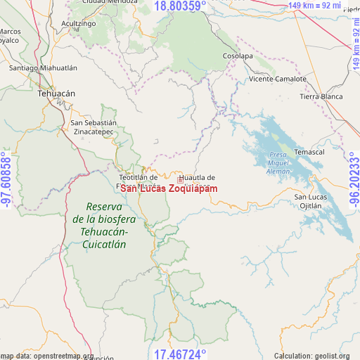
San Lucas Zoquiápam GPS coordinates[2]
18° 8' 12.084" North, 96° 54' 19.62" West
| Map corner | latitude | longitude |
|---|---|---|
| Upper-left | 18.80359°, | -97.60858° |
| Center: | 18.13669°, | -96.90545° |
| Lower-right: | 17.46724°, | -96.20233° |
| Map W x H: | 148.6×148.6 km | = 92.3×92.3mi |
| max Lat: | 32.7° ⇑77.1% North |
| San Lucas Zoquiápam: | 18.13669° |
| min Lat: | ⇓22.9% South 14.53588° |
| min Long | San Lucas Zoqui | max Long |
| -117.105° | -96.90545° | -86.73105° |
| W 76.1%⇐ | ⇒23.9% E |
Elevation
Elevation of San Lucas Zoquiápam is 1760 m = 5774 ft, and this is 506.3 m = 1661 ft above average elevation for this country.
| Max E: |
3497 m = 11473 ft | 38% |
| San Lucas Zoquiápam | 1760 m 5774 ft | |
| Avg. | 1253.7 m = 4113 ft | |
Min E: |
-1 m = -3 ft | 62% |
See also: Mexico elevation on elevation.city.
Geographical zone
San Lucas Zoquiápam is located in North Torrid zone (between Equator and Tropic of Cancer). Distance of this Northern Tropic circle is 589.3 km =366.2 mi to North.| Distance of | km | miles | from San Lucas Zoquiápam |
|---|---|---|---|
| North Pole | 7990.5 | 4965.1 | to North |
| Arctic Circle | 5384.6 | 3345.8 | to North |
| Tropic Cancer | 589.3 | 366.2 | to North |
| Equator | 2016.6 | 1253.1 | to South |


Nearby cities:
15 places around San Lucas Zoquiápam: (largest is in red/bold)
• El Carrizal
6.2 km =3.9 mi,  126°
126°
• Eloxochitlán de Flores Magón
5.5 km =3.4 mi,  35°
35°
• Huautla de Jiménez
6.8 km =4.2 mi,  94°
94°
• La Reforma San Mateo
3.8 km =2.4 mi,  97°
97°
• Loma Chapultepec
7.3 km =4.5 mi,  105°
105°
• Los Frailes
5.9 km =3.7 mi,  230°
230°
• San Isidro Zoquiápam
4.9 km =3 mi,  206°
206°
• San Jerónimo Tecóatl
3.4 km =2.1 mi,  347°
347°
• San Mateo Yoloxochitlán
4 km =2.5 mi,  79°
79°
• San Pedro Ocopetatillo
5.6 km =3.5 mi, 353°
• Santa Cruz Acatepec
4.4 km =2.7 mi,  46°
46°
• Santa Cruz de Juárez
7.6 km =4.7 mi, 78°
• Santa María Teopoxco
6.2 km =3.9 mi,  302°
302°
• Tecuanapam
6.5 km =4 mi, 295°
• Xochitonalco
7.6 km =4.7 mi, 127°
Sources, notices
• [Note1] Compared only with cities in Mexico existing in our database
• [Src1] Map data: © OpenStreetMap contributors (CC-BY-SA)
• [Src2] Other city data from geonames.org with taken over terms of usage.
• [Src3] Geographical zone / Annual Mean Temperature by Robert A. Rohde @ Wikipedia
