Lagunillas geodata
Lagunillas (Guerrero) is a populated place; located in Mexico in America/Mexico_City (GMT-6) time zone. With population of 1,302 people, there are 6663 cities with bigger population in this country. Compared to other cities in Mexico, 88.7% of cities are located further ↑North; 52.7% of cities are located further →East and 70.5% of cities have higher elevation than Lagunillas. Note1


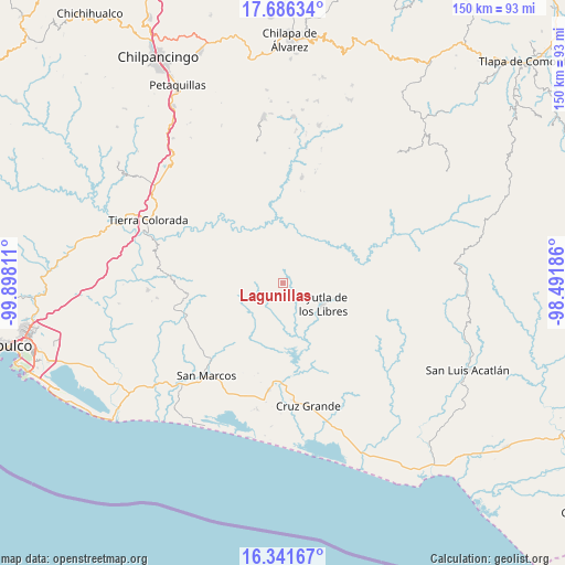
Lagunillas GPS coordinates[2]
17° 0' 54.756" North, 99° 11' 41.928" West
| Map corner | latitude | longitude |
|---|---|---|
| Upper-left | 17.68634°, | -99.89811° |
| Center: | 17.01521°, | -99.19498° |
| Lower-right: | 16.34167°, | -98.49186° |
| Map W x H: | 149.5×149.5 km | = 92.9×92.9mi |
| max Lat: | 32.7° ⇑88.7% North |
| Lagunillas: | 17.01521° |
| min Lat: | ⇓11.3% South 14.53588° |
| min Long | Lagunillas | max Long |
| -117.105° | -99.19498° | -86.73105° |
| W 47.3%⇐ | ⇒52.7% E |
Elevation
Elevation of Lagunillas is 395 m = 1296 ft, and this is 858.7 m = 2817 ft below average elevation for this country.
| Max E: |
3497 m = 11473 ft | 70.5% |
| Avg. | 1253.7 m = 4113 ft | |
| Lagunillas | 395 m = 1296 ft | |
Min E: |
-1 m = -3 ft | 29.5% |
See also: Mexico elevation on elevation.city.
Geographical zone
Lagunillas is located in North Torrid zone (between Equator and Tropic of Cancer). Distance of this Northern Tropic circle is 714 km =443.7 mi to North.| Distance of | km | miles | from Lagunillas |
|---|---|---|---|
| North Pole | 8115.1 | 5042.5 | to North |
| Arctic Circle | 5509.3 | 3423.3 | to North |
| Tropic Cancer | 714 | 443.7 | to North |
| Equator | 1891.9 | 1175.6 | to South |


Nearby cities:
15 places around Lagunillas: (largest is in red/bold)
• Apantla
3.8 km =2.4 mi,  44°
44°
• Buenavista de Allende
2.5 km =1.6 mi,  230°
230°
• Colotepec
3.4 km =2.1 mi,  326°
326°
• Cruz Quemada
2.6 km =1.6 mi,  140°
140°
• El Carrizo
10.5 km =6.5 mi,  195°
195°
• El Charco
10 km =6.2 mi,  300°
300°
• El Cortijo
5.7 km =3.5 mi,  120°
120°
• El Guayabo
8.5 km =5.3 mi,  188°
188°
• El Refugio
2.6 km =1.6 mi,  347°
347°
• Los Magueyitos
9.5 km =5.9 mi,  308°
308°
• Los Tepetates
7.4 km =4.6 mi, 311°
• Mecatepec
5.7 km =3.5 mi, 232°
• San Francisco
9.4 km =5.8 mi,  263°
263°
• Tecoanapa
7.6 km =4.7 mi,  246°
246°
• Tecuantepec
5.9 km =3.7 mi, 254°
Sources, notices
• [Note1] Compared only with cities in Mexico existing in our database
• [Src1] Map data: © OpenStreetMap contributors (CC-BY-SA)
• [Src2] Other city data from geonames.org with taken over terms of usage.
• [Src3] Geographical zone / Annual Mean Temperature by Robert A. Rohde @ Wikipedia
