Colotepec geodata
Colotepec (Guerrero) is a populated place; located in Mexico in America/Mexico_City (GMT-6) time zone. With population of 2,808 people, there are 3155 cities with bigger population in this country. Compared to other cities in Mexico, 88.3% of cities are located further ↑North; 53% of cities are located further →East and 69.8% of cities have higher elevation than Colotepec. Note1


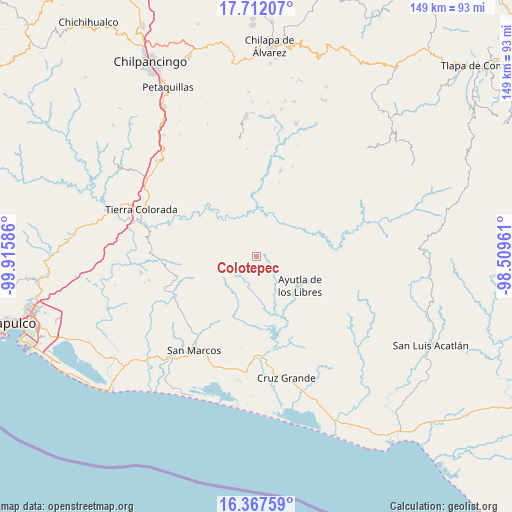
Colotepec GPS coordinates[2]
17° 2' 27.744" North, 99° 12' 45.828" West
| Map corner | latitude | longitude |
|---|---|---|
| Upper-left | 17.71207°, | -99.91586° |
| Center: | 17.04104°, | -99.21273° |
| Lower-right: | 16.36759°, | -98.50961° |
| Map W x H: | 149.5×149.5 km | = 92.9×92.9mi |
| max Lat: | 32.7° ⇑88.3% North |
| Colotepec: | 17.04104° |
| min Lat: | ⇓11.7% South 14.53588° |
| min Long | Colotepec | max Long |
| -117.105° | -99.21273° | -86.73105° |
| W 47%⇐ | ⇒53% E |
Elevation
Elevation of Colotepec is 427 m = 1401 ft, and this is 826.7 m = 2712 ft below average elevation for this country.
| Max E: |
3497 m = 11473 ft | 69.8% |
| Avg. | 1253.7 m = 4113 ft | |
| Colotepec | 427 m = 1401 ft | |
Min E: |
-1 m = -3 ft | 30.2% |
See also: Mexico elevation on elevation.city.
Geographical zone
Colotepec is located in North Torrid zone (between Equator and Tropic of Cancer). Distance of this Northern Tropic circle is 711.1 km =441.9 mi to North.| Distance of | km | miles | from Colotepec |
|---|---|---|---|
| North Pole | 8112.3 | 5040.7 | to North |
| Arctic Circle | 5506.4 | 3421.5 | to North |
| Tropic Cancer | 711.1 | 441.9 | to North |
| Equator | 1894.8 | 1177.4 | to South |


Nearby cities:
15 places around Colotepec: (largest is in red/bold)
• Apantla
4.6 km =2.9 mi,  91°
91°
• Buenavista de Allende
4.5 km =2.8 mi,  180°
180°
• Cruz Quemada
6 km =3.7 mi,  144°
144°
• El Charco
7.1 km =4.4 mi,  287°
287°
• El Cortijo
8.9 km =5.5 mi,  130°
130°
• El Guayabo
11.3 km =7 mi, 176°
• El Refugio
1.3 km =0.8 mi,  103°
103°
• Lagunillas
3.4 km =2.1 mi,  146°
146°
• Los Magueyitos
6.3 km =3.9 mi,  298°
298°
• Los Saucitos
11.1 km =6.9 mi,  236°
236°
• Los Tepetates
4.2 km =2.6 mi, 298°
• Mecatepec
6.9 km =4.3 mi,  202°
202°
• San Francisco
8.4 km =5.2 mi, 242°
• Tecoanapa
7.8 km =4.8 mi,  220°
220°
• Tecuantepec
5.9 km =3.7 mi, 220°
Sources, notices
• [Note1] Compared only with cities in Mexico existing in our database
• [Src1] Map data: © OpenStreetMap contributors (CC-BY-SA)
• [Src2] Other city data from geonames.org with taken over terms of usage.
• [Src3] Geographical zone / Annual Mean Temperature by Robert A. Rohde @ Wikipedia
