Nuevo San Juan Chamula geodata
Nuevo San Juan Chamula (Chiapas) is a populated place; located in Mexico in America/Mexico_City (GMT-6) time zone. With population of 506 people, there are 16626 cities with bigger population in this country. Compared to other cities in Mexico, 90.3% of cities are located further ↑North; 86.5% of cities are located further ←West and 59.3% of cities have higher elevation than Nuevo San Juan Chamula. Note1


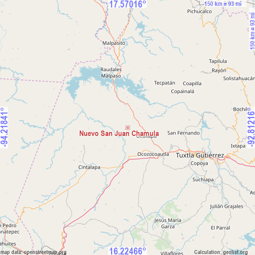
Nuevo San Juan Chamula GPS coordinates[2]
16° 53' 54.996" North, 93° 30' 55.008" West
| Map corner | latitude | longitude |
|---|---|---|
| Upper-left | 17.57016°, | -94.21841° |
| Center: | 16.89861°, | -93.51528° |
| Lower-right: | 16.22466°, | -92.81216° |
| Map W x H: | 149.6×149.6 km | = 93×93mi |
| max Lat: | 32.7° ⇑90.3% North |
| Nuevo San Juan Chamula: | 16.89861° |
| min Lat: | ⇓9.7% South 14.53588° |
| min Long | Nuevo San Juan | max Long |
| -117.105° | -93.51528° | -86.73105° |
| W 86.5%⇐ | ⇒13.5% E |
Elevation
Elevation of Nuevo San Juan Chamula is 1035 m = 3396 ft, and this is 218.7 m = 718 ft below average elevation for this country.
| Max E: |
3497 m = 11473 ft | 59.3% |
| Avg. | 1253.7 m = 4113 ft | |
| Nuevo San Juan Chamula | 1035 m = 3396 ft | |
Min E: |
-1 m = -3 ft | 40.7% |
See also: Mexico elevation on elevation.city.
Geographical zone
Nuevo San Juan Chamula is located in North Torrid zone (between Equator and Tropic of Cancer). Distance of this Northern Tropic circle is 727 km =451.7 mi to North.| Distance of | km | miles | from Nuevo San Juan Chamula |
|---|---|---|---|
| North Pole | 8128.1 | 5050.6 | to North |
| Arctic Circle | 5522.2 | 3431.3 | to North |
| Tropic Cancer | 727 | 451.7 | to North |
| Equator | 1878.9 | 1167.5 | to South |


Nearby cities:
15 places around Nuevo San Juan Chamula: (largest is in red/bold)
• Ach'Lum Tierra Nueva
12.3 km =7.6 mi,  356°
356°
• Adolfo López Mateos
21.1 km =13.1 mi,  264°
264°
• Alfonso Moguel
25.7 km =16 mi,  177°
177°
• Ciudad Maya
27.6 km =17.1 mi,  129°
129°
• Efraín A. Gutiérrez
23.3 km =14.5 mi,  94°
94°
• Espinal de Morelos
23.1 km =14.4 mi,  156°
156°
• General Francisco Villa
12.8 km =8 mi,  26°
26°
• Ignacio Zaragoza
24.9 km =15.5 mi,  44°
44°
• Juan de Grijalva
17.9 km =11.1 mi, 359°
• Las Maravillas
21.8 km =13.5 mi,  71°
71°
• Las Pimientas
8.3 km =5.2 mi,  47°
47°
• Nuevo Mezcalapa
10.9 km =6.8 mi, 40°
• Ocozocoautla de Espinosa
21.3 km =13.2 mi,  135°
135°
• Piedra Parada
11.5 km =7.1 mi, 133°
• Vicente Guerrero
27.5 km =17.1 mi,  195°
195°
Sources, notices
• [Note1] Compared only with cities in Mexico existing in our database
• [Src1] Map data: © OpenStreetMap contributors (CC-BY-SA)
• [Src2] Other city data from geonames.org with taken over terms of usage.
• [Src3] Geographical zone / Annual Mean Temperature by Robert A. Rohde @ Wikipedia
