Quilate Nuevo geodata
Quilate Nuevo (Veracruz) is a populated place; located in Mexico in America/Mexico_City (GMT-6) time zone. With population of 517 people, there are 16282 cities with bigger population in this country. Compared to other cities in Mexico, 54.6% of cities are located further ↓South; 75.1% of cities are located further ←West and 64.1% of cities have higher elevation than Quilate Nuevo. Note1


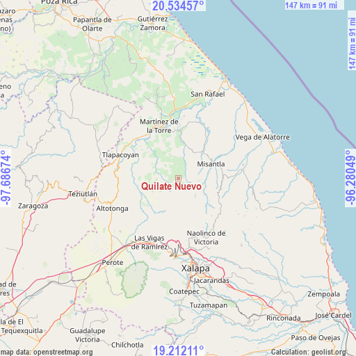
Quilate Nuevo GPS coordinates[2]
19° 52' 28.992" North, 96° 59' 0.996" West
| Map corner | latitude | longitude |
|---|---|---|
| Upper-left | 20.53457°, | -97.68674° |
| Center: | 19.87472°, | -96.98361° |
| Lower-right: | 19.21211°, | -96.28049° |
| Map W x H: | 147×147 km | = 91.3×91.3mi |
| max Lat: | 32.7° ⇑45.4% North |
| Quilate Nuevo: | 19.87472° |
| min Lat: | ⇓54.6% South 14.53588° |
| min Long | Quilate Nuevo | max Long |
| -117.105° | -96.98361° | -86.73105° |
| W 75.1%⇐ | ⇒24.9% E |
Elevation
Elevation of Quilate Nuevo is 745 m = 2444 ft, and this is 508.7 m = 1669 ft below average elevation for this country.
| Max E: |
3497 m = 11473 ft | 64.1% |
| Avg. | 1253.7 m = 4113 ft | |
| Quilate Nuevo | 745 m = 2444 ft | |
Min E: |
-1 m = -3 ft | 35.9% |
See also: Mexico elevation on elevation.city.
Geographical zone
Quilate Nuevo is located in North Torrid zone (between Equator and Tropic of Cancer). Distance of this Northern Tropic circle is 396.1 km =246.1 mi to North.| Distance of | km | miles | from Quilate Nuevo |
|---|---|---|---|
| North Pole | 7797.2 | 4845 | to North |
| Arctic Circle | 5191.3 | 3225.7 | to North |
| Tropic Cancer | 396.1 | 246.1 | to North |
| Equator | 2209.9 | 1373.2 | to South |


Nearby cities:
15 places around Quilate Nuevo: (largest is in red/bold)
• Almanza
12.1 km =7.5 mi,  330°
330°
• El Azotal
5.6 km =3.5 mi,  337°
337°
• Ignacio Zaragoza
12.9 km =8 mi,  18°
18°
• La Prensa
13.7 km =8.5 mi,  230°
230°
• Las Truchas
14.6 km =9.1 mi, 227°
• Misantla
15.1 km =9.4 mi,  65°
65°
• Pahua Hueca
12.2 km =7.6 mi,  322°
322°
• Paso Blanco
11.6 km =7.2 mi,  93°
93°
• Plan de Arroyos
13.3 km =8.3 mi,  278°
278°
• Pueblo Viejo
13.2 km =8.2 mi,  119°
119°
• Santa Cruz Hidalgo
14.9 km =9.3 mi,  46°
46°
• Temimilco
14.1 km =8.8 mi,  235°
235°
• Tenochtitlán
10.1 km =6.3 mi,  135°
135°
• Tierra Nueva
8 km =5 mi, 334°
• Vicente Guerrero
8.5 km =5.3 mi,  98°
98°
Sources, notices
• [Note1] Compared only with cities in Mexico existing in our database
• [Src1] Map data: © OpenStreetMap contributors (CC-BY-SA)
• [Src2] Other city data from geonames.org with taken over terms of usage.
• [Src3] Geographical zone / Annual Mean Temperature by Robert A. Rohde @ Wikipedia
