Buena Vista geodata
Buena Vista (Puebla) is a populated place; located in Mexico in America/Mexico_City (GMT-6) time zone. With population of 1,353 people, there are 6427 cities with bigger population in this country. Compared to other cities in Mexico, 59.7% of cities are located further ↓South; 70% of cities are located further ←West and 78.2% of cities have higher elevation than Buena Vista. Note1


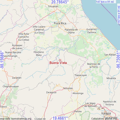
Buena Vista GPS coordinates[2]
20° 7' 39.612" North, 97° 27' 13.428" West
| Map corner | latitude | longitude |
|---|---|---|
| Upper-left | 20.78645°, | -98.15686° |
| Center: | 20.12767°, | -97.45373° |
| Lower-right: | 19.4661°, | -96.75061° |
| Map W x H: | 146.8×146.8 km | = 91.2×91.2mi |
| max Lat: | 32.7° ⇑40.3% North |
| Buena Vista: | 20.12767° |
| min Lat: | ⇓59.7% South 14.53588° |
| min Long | Buena Vista | max Long |
| -117.105° | -97.45373° | -86.73105° |
| W 70%⇐ | ⇒30% E |
Elevation
Elevation of Buena Vista is 127 m = 417 ft, and this is 1126.7 m = 3697 ft below average elevation for this country.
| Max E: |
3497 m = 11473 ft | 78.2% |
| Avg. | 1253.7 m = 4113 ft | |
| Buena Vista | 127 m = 417 ft | |
Min E: |
-1 m = -3 ft | 21.8% |
See also: Mexico elevation on elevation.city.
Geographical zone
Buena Vista is located in North Torrid zone (between Equator and Tropic of Cancer). Distance of this Northern Tropic circle is 367.9 km =228.6 mi to North.| Distance of | km | miles | from Buena Vista |
|---|---|---|---|
| North Pole | 7769.1 | 4827.5 | to North |
| Arctic Circle | 5163.2 | 3208.3 | to North |
| Tropic Cancer | 367.9 | 228.6 | to North |
| Equator | 2238 | 1390.6 | to South |


Nearby cities:
15 places around Buena Vista: (largest is in red/bold)
• Ayotoxco de Guerrero
5.8 km =3.6 mi,  127°
127°
• Cuauhtapanaloyan
6.1 km =3.8 mi,  183°
183°
• Gachupinate
5.5 km =3.4 mi,  104°
104°
• La Lima
6.2 km =3.9 mi,  51°
51°
• Reyes de Vallarta
8.4 km =5.2 mi,  254°
254°
• San Antonio Rayón
3.5 km =2.2 mi,  239°
239°
• Santiago Yancuictlalpan
7.7 km =4.8 mi,  194°
194°
• Tacuapan
5.5 km =3.4 mi,  206°
206°
• Tecpantzingo
3.3 km =2.1 mi, 205°
• Tecuantepec
5.2 km =3.2 mi,  291°
291°
• Tenampulco
7 km =4.3 mi, 46°
• Tepetitán Reyeshogpan de Hidalgo
6.4 km =4 mi,  220°
220°
• Tuzamapan Xiloxochico
8.6 km =5.3 mi,  204°
204°
• Xalcuahuta
7.5 km =4.7 mi,  234°
234°
• Yohualichan
9 km =5.6 mi, 215°
Sources, notices
• [Note1] Compared only with cities in Mexico existing in our database
• [Src1] Map data: © OpenStreetMap contributors (CC-BY-SA)
• [Src2] Other city data from geonames.org with taken over terms of usage.
• [Src3] Geographical zone / Annual Mean Temperature by Robert A. Rohde @ Wikipedia
