Tenampulco geodata
Tenampulco (Puebla) is a seat of a second-order administrative division; located in Mexico in America/Mexico_City (GMT-6) time zone. With population of 1,109 people, there are 7837 cities with bigger population in this country. Compared to other cities in Mexico, 60.7% of cities are located further ↓South; 70.5% of cities are located further ←West and 74.6% of cities have higher elevation than Tenampulco. Note1


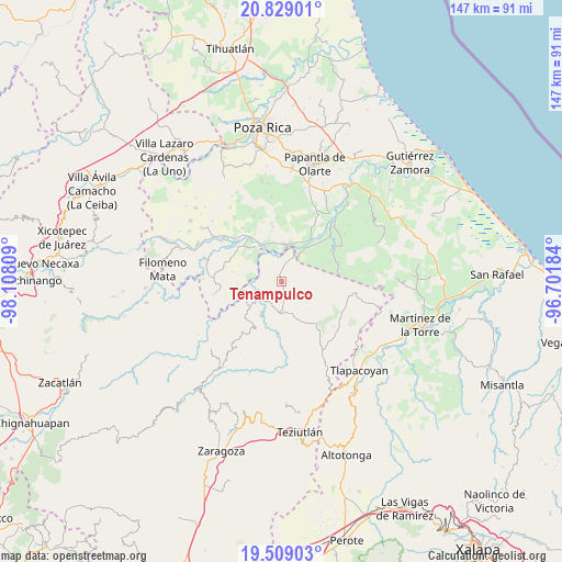
Tenampulco GPS coordinates[2]
20° 10' 13.512" North, 97° 24' 17.856" West
| Map corner | latitude | longitude |
|---|---|---|
| Upper-left | 20.82901°, | -98.10809° |
| Center: | 20.17042°, | -97.40496° |
| Lower-right: | 19.50903°, | -96.70184° |
| Map W x H: | 146.8×146.8 km | = 91.2×91.2mi |
| max Lat: | 32.7° ⇑39.3% North |
| Tenampulco: | 20.17042° |
| min Lat: | ⇓60.7% South 14.53588° |
| min Long | Tenampulco | max Long |
| -117.105° | -97.40496° | -86.73105° |
| W 70.5%⇐ | ⇒29.5% E |
Elevation
Elevation of Tenampulco is 232 m = 761 ft, and this is 1021.7 m = 3352 ft below average elevation for this country.
| Max E: |
3497 m = 11473 ft | 74.6% |
| Avg. | 1253.7 m = 4113 ft | |
| Tenampulco | 232 m = 761 ft | |
Min E: |
-1 m = -3 ft | 25.4% |
See also: Mexico elevation on elevation.city.
Geographical zone
Tenampulco is located in North Torrid zone (between Equator and Tropic of Cancer). Distance of this Northern Tropic circle is 363.2 km =225.7 mi to North.| Distance of | km | miles | from Tenampulco |
|---|---|---|---|
| North Pole | 7764.3 | 4824.5 | to North |
| Arctic Circle | 5158.4 | 3205.3 | to North |
| Tropic Cancer | 363.2 | 225.7 | to North |
| Equator | 2242.7 | 1393.5 | to South |


Nearby cities:
15 places around Tenampulco: (largest is in red/bold)
• Ayotoxco de Guerrero
8.3 km =5.2 mi,  183°
183°
• Belisario Domínguez
11.6 km =7.2 mi,  66°
66°
• Buena Vista
7 km =4.3 mi,  226°
226°
• Comalteco
11.1 km =6.9 mi,  321°
321°
• El Cedral
11.7 km =7.3 mi,  38°
38°
• El Chacal
8.2 km =5.1 mi,  314°
314°
• Espinal
9.8 km =6.1 mi,  2°
2°
• Gachupinate
6.1 km =3.8 mi, 178°
• Guadalupe Victoria
10.7 km =6.6 mi,  18°
18°
• La Lima
0.9 km =0.6 mi,  193°
193°
• Pajasco Limonar
11.5 km =7.1 mi,  27°
27°
• San Antonio Rayón
10.4 km =6.5 mi, 231°
• Tecpantzingo
10.1 km =6.3 mi,  220°
220°
• Tecuantepec
10.3 km =6.4 mi,  254°
254°
• Tenexate
5.8 km =3.6 mi,  121°
121°
Sources, notices
• [Note1] Compared only with cities in Mexico existing in our database
• [Src1] Map data: © OpenStreetMap contributors (CC-BY-SA)
• [Src2] Other city data from geonames.org with taken over terms of usage.
• [Src3] Geographical zone / Annual Mean Temperature by Robert A. Rohde @ Wikipedia
