Escolasticas geodata
Escolasticas (Querétaro) is a populated place; located in Mexico in America/Mexico_City (GMT-6) time zone. With population of 2,510 people, there are 3523 cities with bigger population in this country. Compared to other cities in Mexico, 66.2% of cities are located further ↓South; 66.6% of cities are located further →East and 79.1% of cities have lower elevation than Escolasticas. Note1


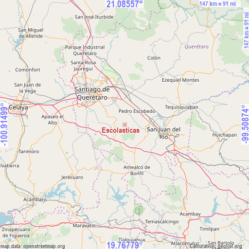
Escolasticas GPS coordinates[2]
20° 25' 41.124" North, 100° 12' 42.696" West
| Map corner | latitude | longitude |
|---|---|---|
| Upper-left | 21.08557°, | -100.91499° |
| Center: | 20.42809°, | -100.21186° |
| Lower-right: | 19.76779°, | -99.50874° |
| Map W x H: | 146.5×146.5 km | = 91×91mi |
| max Lat: | 32.7° ⇑33.8% North |
| Escolasticas: | 20.42809° |
| min Lat: | ⇓66.2% South 14.53588° |
| min Long | Escolasticas | max Long |
| -117.105° | -100.21186° | -86.73105° |
| W 33.4%⇐ | ⇒66.6% E |
Elevation
Elevation of Escolasticas is 2119 m = 6952 ft, and this is 865.3 m = 2839 ft above average elevation for this country.
| Max E: |
3497 m = 11473 ft | 20.9% |
| Escolasticas | 2119 m 6952 ft | |
| Avg. | 1253.7 m = 4113 ft | |
Min E: |
-1 m = -3 ft | 79.1% |
See also: Mexico elevation on elevation.city.
Geographical zone
Escolasticas is located in North Torrid zone (between Equator and Tropic of Cancer). Distance of this Northern Tropic circle is 334.5 km =207.8 mi to North.| Distance of | km | miles | from Escolasticas |
|---|---|---|---|
| North Pole | 7735.7 | 4806.7 | to North |
| Arctic Circle | 5129.8 | 3187.5 | to North |
| Tropic Cancer | 334.5 | 207.8 | to North |
| Equator | 2271.4 | 1411.4 | to South |


Nearby cities:
15 places around Escolasticas: (largest is in red/bold)
• Ajuchitlancito
5.3 km =3.3 mi,  355°
355°
• Arcila
10.8 km =6.7 mi,  100°
100°
• El Coto
8.9 km =5.5 mi,  114°
114°
• Guadalupe Primero
11.4 km =7.1 mi,  302°
302°
• Huimilpan
9.2 km =5.7 mi,  227°
227°
• La Ceja
7.7 km =4.8 mi, 226°
• La D
6.3 km =3.9 mi,  77°
77°
• La Lira
7.4 km =4.6 mi,  44°
44°
• La Palma
11.2 km =7 mi,  20°
20°
• Lagunillas
9.3 km =5.8 mi,  291°
291°
• Los Cues
9.9 km =6.2 mi,  326°
326°
• Pedro Escobedo
10.7 km =6.6 mi, 42°
• San Antonio la D
5.1 km =3.2 mi, 98°
• San Antonio la Galera
11 km =6.8 mi,  345°
345°
• San Cirilo
2 km =1.2 mi,  147°
147°
Sources, notices
• [Note1] Compared only with cities in Mexico existing in our database
• [Src1] Map data: © OpenStreetMap contributors (CC-BY-SA)
• [Src2] Other city data from geonames.org with taken over terms of usage.
• [Src3] Geographical zone / Annual Mean Temperature by Robert A. Rohde @ Wikipedia
