Kota Tinggi geodata
Kota Tinggi (Johor) is a populated place; located in Malaysia in Asia/Kuala_Lumpur (GMT+8) time zone. With population of 52,743 people, there are 63 cities with bigger population in this country. Compared to other cities in Malaysia, 93.8% of cities are located further ↑North; 80.9% of cities are located further ←West and 55.6% of cities have lower elevation than Kota Tinggi. Note1


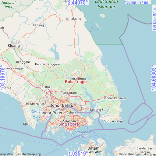
Kota Tinggi GPS coordinates[2]
1° 44' 17.16" North, 103° 53' 59.64" East
| Map corner | latitude | longitude |
|---|---|---|
| Upper-left | 2.44075°, | 103.19678° |
| Center: | 1.7381°, | 103.8999° |
| Lower-right: | 1.03519°, | 104.60303° |
| Map W x H: | 156.3×156.3 km | = 97.1×97.1mi |
| max Lat: | 6.88732° ⇑93.8% North |
| Kota Tinggi: | 1.7381° |
| min Lat: | ⇓6.2% South 1.24722° |
| min Long | Kota Tinggi | max Long |
| 99.68252° | 103.8999° | 118.61119° |
| W 80.9%⇐ | ⇒19.1% E |
Elevation
Elevation of Kota Tinggi is 17 m = 56 ft, and this is 27.7 m = 91 ft below average elevation for this country.
| Max E: |
1488 m = 4882 ft | 44.4% |
| Avg. | 44.7 m = 147 ft | |
| Kota Tinggi | 17 m = 56 ft | |
Min E: |
0 m = 0 ft | 55.6% |
See also: Kota Tinggi elevation on elevation.city.
Geographical zone
Kota Tinggi is located in North Torrid zone (between Equator and Tropic of Cancer). Distance of Equator is 193.3 km =120.1 mi to South.| Distance of | km | miles | from Kota Tinggi |
|---|---|---|---|
| North Pole | 9813.8 | 6098 | to North |
| Arctic Circle | 7207.9 | 4478.8 | to North |
| Tropic Cancer | 2412.7 | 1499.2 | to North |
| Equator | 193.3 | 120.1 | to South |


Nearby cities:
15 places around Kota Tinggi: (largest is in red/bold)
• Batu Pahat
108.3 km =67.3 mi,  276°
276°
• Johor Bahru
34.2 km =21.3 mi,  207°
207°
• Kampung Pasir Gudang Baru
29.6 km =18.4 mi,  184°
184°
• Kampung Simpang Renggam
67.4 km =41.9 mi, 278°
• Kelapa Sawit
41.5 km =25.8 mi,  259°
259°
• Kluang
72.5 km =45 mi,  296°
296°
• Kulai
34.2 km =21.3 mi,  254°
254°
• Mersing
77.3 km =48 mi,  355°
355°
• Parit Raja
88.7 km =55.1 mi, 279°
• Pekan Nenas
49.8 km =30.9 mi,  239°
239°
• Pontian Kechil
63.2 km =39.3 mi, 243°
• Skudai
35 km =21.7 mi,  230°
230°
• Taman Senai
32.5 km =20.2 mi, 241°
• Ulu Tiram
17.9 km =11.1 mi, 211°
• Yong Peng
97.6 km =60.6 mi,  288°
288°
Sources, notices
• [Note1] Compared only with cities in Malaysia existing in our database
• [Src1] Map data: © OpenStreetMap contributors (CC-BY-SA)
• [Src2] Other city data from geonames.org with taken over terms of usage.
• [Src3] Geographical zone / Annual Mean Temperature by Robert A. Rohde @ Wikipedia
