Skudai geodata
Skudai (Johor) is a section of populated place; located in Malaysia in Asia/Kuala_Lumpur (GMT+8) time zone. With population of 159,733 people, there are 27 cities with bigger population in this country. Compared to other cities in Malaysia, 97.2% of cities are located further ↑North; 78.1% of cities are located further ←West and 79.8% of cities have lower elevation than Skudai. Note1


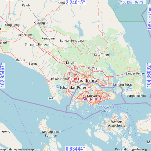
Skudai GPS coordinates[2]
1° 32' 14.676" North, 103° 39' 28.044" East
| Map corner | latitude | longitude |
|---|---|---|
| Upper-left | 2.24015°, | 102.95467° |
| Center: | 1.53741°, | 103.65779° |
| Lower-right: | 0.83444°, | 104.36092° |
| Map W x H: | 156.3×156.3 km | = 97.1×97.1mi |
| max Lat: | 6.88732° ⇑97.2% North |
| Skudai: | 1.53741° |
| min Lat: | ⇓2.8% South 1.24722° |
| min Long | Skudai | max Long |
| 99.68252° | 103.65779° | 118.61119° |
| W 78.1%⇐ | ⇒21.9% E |
Elevation
Elevation of Skudai is 40 m = 131 ft, and this is 4.7 m = 15 ft below average elevation for this country.
| Max E: |
1488 m = 4882 ft | 20.2% |
| Avg. | 44.7 m = 147 ft | |
| Skudai | 40 m = 131 ft | |
Min E: |
0 m = 0 ft | 79.8% |
See also: Skudai elevation on elevation.city.
Geographical zone
Skudai is located in North Torrid zone (between Equator and Tropic of Cancer). Distance of Equator is 170.9 km =106.2 mi to South.| Distance of | km | miles | from Skudai |
|---|---|---|---|
| North Pole | 9836.1 | 6111.9 | to North |
| Arctic Circle | 7230.2 | 4492.6 | to North |
| Tropic Cancer | 2435 | 1513 | to North |
| Equator | 170.9 | 106.2 | to South |


Nearby cities:
15 places around Skudai: (largest is in red/bold)
• Batu Pahat
88 km =54.7 mi,  293°
293°
• Johor Bahru
13.7 km =8.5 mi,  125°
125°
• Kampung Pasir Gudang Baru
25.5 km =15.8 mi,  106°
106°
• Kampung Simpang Renggam
51.2 km =31.8 mi,  309°
309°
• Kelapa Sawit
20.2 km =12.6 mi,  316°
316°
• Kluang
66.6 km =41.4 mi,  325°
325°
• Kota Tinggi
35 km =21.7 mi,  50°
50°
• Kulai
14.5 km =9 mi,  335°
335°
• Mersing
101.4 km =63 mi,  11°
11°
• Parit Raja
70.9 km =44.1 mi,  301°
301°
• Pekan Nenas
16.3 km =10.1 mi,  259°
259°
• Pontian Kechil
30.3 km =18.8 mi, 259°
• Taman Senai
7.2 km =4.5 mi,  345°
345°
• Ulu Tiram
19 km =11.8 mi,  68°
68°
• Yong Peng
84.4 km =52.4 mi, 308°
Sources, notices
• [Note1] Compared only with cities in Malaysia existing in our database
• [Src1] Map data: © OpenStreetMap contributors (CC-BY-SA)
• [Src2] Other city data from geonames.org with taken over terms of usage.
• [Src3] Geographical zone / Annual Mean Temperature by Robert A. Rohde @ Wikipedia
