Mersing geodata
Mersing (Johor) is a populated place; located in Malaysia in Asia/Kuala_Lumpur (GMT+8) time zone. With population of 22,007 people, there are 111 cities with bigger population in this country. Compared to other cities in Malaysia, 79.2% of cities are located further ↑North; 79.8% of cities are located further ←West and 77% of cities have higher elevation than Mersing. Note1


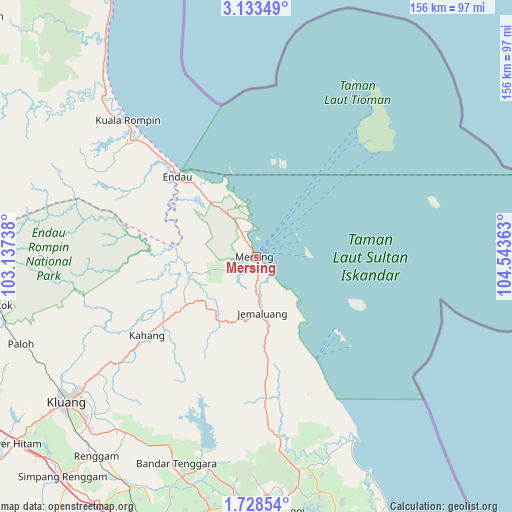
Mersing GPS coordinates[2]
2° 25' 52.32" North, 103° 50' 25.8" East
| Map corner | latitude | longitude |
|---|---|---|
| Upper-left | 3.13349°, | 103.13738° |
| Center: | 2.4312°, | 103.8405° |
| Lower-right: | 1.72854°, | 104.54363° |
| Map W x H: | 156.2×156.2 km | = 97.1×97.1mi |
| max Lat: | 6.88732° ⇑79.2% North |
| Mersing: | 2.4312° |
| min Lat: | ⇓20.8% South 1.24722° |
| min Long | Mersing | max Long |
| 99.68252° | 103.8405° | 118.61119° |
| W 79.8%⇐ | ⇒20.2% E |
Elevation
Elevation of Mersing is 8 m = 26 ft, and this is 36.7 m = 120 ft below average elevation for this country.
| Max E: |
1488 m = 4882 ft | 77% |
| Avg. | 44.7 m = 147 ft | |
| Mersing | 8 m = 26 ft | |
Min E: |
0 m = 0 ft | 23% |
See also: Malaysia elevation on elevation.city.
Geographical zone
Mersing is located in North Torrid zone (between Equator and Tropic of Cancer). Distance of Equator is 270.3 km =168 mi to South.| Distance of | km | miles | from Mersing |
|---|---|---|---|
| North Pole | 9736.7 | 6050.1 | to North |
| Arctic Circle | 7130.8 | 4430.9 | to North |
| Tropic Cancer | 2335.6 | 1451.3 | to North |
| Equator | 270.3 | 168 | to South |


Nearby cities:
15 places around Mersing: (largest is in red/bold)
• Chaah
90.3 km =56.1 mi,  257°
257°
• Johor Bahru
107.8 km =67 mi,  184°
184°
• Kampung Pasir Gudang Baru
106.7 km =66.3 mi, 177°
• Kampung Simpang Renggam
90 km =55.9 mi,  221°
221°
• Kampung Tekek
55.4 km =34.4 mi,  39°
39°
• Kelapa Sawit
91.3 km =56.7 mi,  201°
201°
• Kluang
73.3 km =45.5 mi,  232°
232°
• Kota Tinggi
77.3 km =48 mi, 175°
• Kulai
90.1 km =56 mi, 197°
• Labis
91.2 km =56.7 mi,  266°
266°
• Parit Raja
102.3 km =63.6 mi, 232°
• Skudai
101.4 km =63 mi,  191°
191°
• Taman Senai
95 km =59 mi, 193°
• Ulu Tiram
92.5 km =57.5 mi, 181°
• Yong Peng
97.8 km =60.8 mi,  241°
241°
Sources, notices
• [Note1] Compared only with cities in Malaysia existing in our database
• [Src1] Map data: © OpenStreetMap contributors (CC-BY-SA)
• [Src2] Other city data from geonames.org with taken over terms of usage.
• [Src3] Geographical zone / Annual Mean Temperature by Robert A. Rohde @ Wikipedia
