Kuala Lipis geodata
Kuala Lipis (Pahang) is a populated place; located in Malaysia in Asia/Kuala_Lumpur (GMT+8) time zone. With population of 15,448 people, there are 141 cities with bigger population in this country. Compared to other cities in Malaysia, 53.4% of cities are located further ↓South; 53.4% of cities are located further →East and 96.1% of cities have lower elevation than Kuala Lipis. Note1


Kuala Lipis GPS coordinates[2]
4° 11' 3.12" North, 102° 2' 48.48" East
| Map corner | latitude | longitude |
|---|---|---|
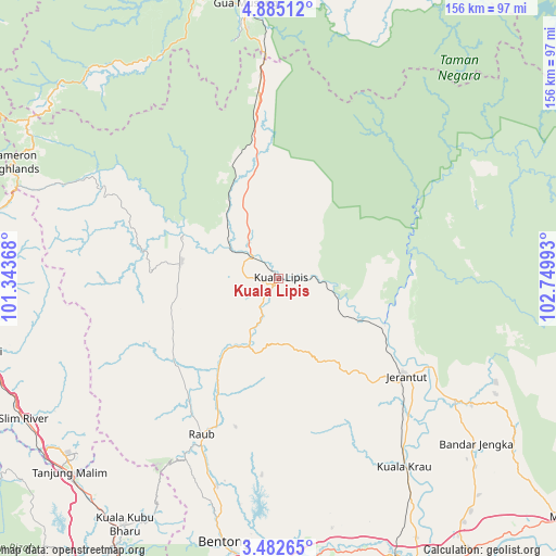
| Upper-left | 4.88512°, | 101.34368° |
| Center: | 4.1842°, | 102.0468° |
| Lower-right: | 3.48265°, | 102.74993° |
| Map W x H: | 155.9×155.9 km | = 96.9×96.9mi |
| max Lat: | 6.88732° ⇑46.6% North |
| Kuala Lipis: | 4.1842° |
| min Lat: | ⇓53.4% South 1.24722° |
| min Long | Kuala Lipis | max Long |
| 99.68252° | 102.0468° | 118.61119° |
| W 46.6%⇐ | ⇒53.4% E |
Elevation
Elevation of Kuala Lipis is 99 m = 325 ft, and this is 54.3 m = 178 ft above average elevation for this country.
| Max E: |
1488 m = 4882 ft | 3.9% |
| Kuala Lipis | 99 m 325 ft | |
| Avg. | 44.7 m = 147 ft | |
Min E: |
0 m = 0 ft | 96.1% |
See also: Malaysia elevation on elevation.city.
Geographical zone
Kuala Lipis is located in North Torrid zone (between Equator and Tropic of Cancer). Distance of Equator is 465.2 km =289.1 mi to South.| Distance of | km | miles | from Kuala Lipis |
|---|---|---|---|
| North Pole | 9541.8 | 5929 | to North |
| Arctic Circle | 6935.9 | 4309.8 | to North |
| Tropic Cancer | 2140.7 | 1330.2 | to North |
| Equator | 465.2 | 289.1 | to South |


Nearby cities:
15 places around Kuala Lipis: (largest is in red/bold)
• Batang Berjuntai
113.2 km =70.3 mi,  218°
218°
• Bentong Town
75.2 km =46.7 mi,  191°
191°
• Bidur
85 km =52.8 mi,  264°
264°
• Gua Musang
78.3 km =48.7 mi,  353°
353°
• Jerantut
44.6 km =27.7 mi,  128°
128°
• Kampar
100.3 km =62.3 mi,  277°
277°
• Kampung Bukit Tinggi, Bentong
96 km =59.7 mi, 194°
• Mentekab
84.6 km =52.6 mi,  156°
156°
• Raub
48.6 km =30.2 mi,  205°
205°
• Rawang
109.2 km =67.9 mi, 208°
• Serendah
103.5 km =64.3 mi, 208°
• Tanah Rata
80.6 km =50.1 mi,  292°
292°
• Tapah Road
93.9 km =58.3 mi,  268°
268°
• Teluk Intan
115.2 km =71.6 mi, 261°
• Temerluh
91.4 km =56.8 mi,  153°
153°
Sources, notices
• [Note1] Compared only with cities in Malaysia existing in our database
• [Src1] Map data: © OpenStreetMap contributors (CC-BY-SA)
• [Src2] Other city data from geonames.org with taken over terms of usage.
• [Src3] Geographical zone / Annual Mean Temperature by Robert A. Rohde @ Wikipedia
