Jitra geodata
Jitra (Kedah) is a populated place; located in Malaysia in Asia/Kuala_Lumpur (GMT+8) time zone. With population of 63,489 people, there are 53 cities with bigger population in this country. Compared to other cities in Malaysia, 92.7% of cities are located further ↓South; 87.6% of cities are located further →East and 55.6% of cities have lower elevation than Jitra. Note1


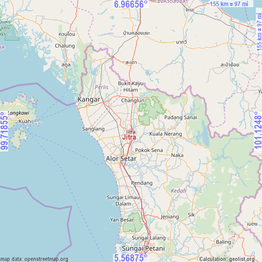
Jitra GPS coordinates[2]
6° 16' 5.232" North, 100° 25' 18.012" East
| Map corner | latitude | longitude |
|---|---|---|
| Upper-left | 6.96656°, | 99.71855° |
| Center: | 6.26812°, | 100.42167° |
| Lower-right: | 5.56875°, | 101.1248° |
| Map W x H: | 155.4×155.4 km | = 96.6×96.6mi |
| max Lat: | 6.88732° ⇑7.3% North |
| Jitra: | 6.26812° |
| min Lat: | ⇓92.7% South 1.24722° |
| min Long | Jitra | max Long |
| 99.68252° | 100.42167° | 118.61119° |
| W 12.4%⇐ | ⇒87.6% E |
Elevation
Elevation of Jitra is 17 m = 56 ft, and this is 27.7 m = 91 ft below average elevation for this country.
| Max E: |
1488 m = 4882 ft | 44.4% |
| Avg. | 44.7 m = 147 ft | |
| Jitra | 17 m = 56 ft | |
Min E: |
0 m = 0 ft | 55.6% |
See also: Jitra elevation on elevation.city.
Geographical zone
Jitra is located in North Torrid zone (between Equator and Tropic of Cancer). Distance of Equator is 696.9 km =433 mi to South.| Distance of | km | miles | from Jitra |
|---|---|---|---|
| North Pole | 9310.1 | 5785 | to North |
| Arctic Circle | 6704.2 | 4165.8 | to North |
| Tropic Cancer | 1909 | 1186.2 | to North |
| Equator | 696.9 | 433 | to South |


Nearby cities:
15 places around Jitra: (largest is in red/bold)
• Alor Setar
17.7 km =11 mi,  202°
202°
• Ayer Hangat
68.4 km =42.5 mi,  284°
284°
• Bedong
60.9 km =37.8 mi,  170°
170°
• Gurun
50.5 km =31.4 mi, 173°
• Kampung Bukit Hantu
71.3 km =44.3 mi, 278°
• Kampung Kilim
65 km =40.4 mi, 283°
• Kangar
31.3 km =19.4 mi,  308°
308°
• Kuah
64.3 km =40 mi, 275°
• Kuala Kedah
23 km =14.3 mi,  215°
215°
• Kuala Perlis
35.1 km =21.8 mi,  294°
294°
• Kuala Teriang
78.8 km =49 mi, 277°
• Padang Mat Sirat
76.6 km =47.6 mi, 277°
• Pantai Cenang
76.7 km =47.7 mi,  272°
272°
• Sungai Petani
69.4 km =43.1 mi, 173°
• Tanjung Rhu
69.5 km =43.2 mi, 287°
Sources, notices
• [Note1] Compared only with cities in Malaysia existing in our database
• [Src1] Map data: © OpenStreetMap contributors (CC-BY-SA)
• [Src2] Other city data from geonames.org with taken over terms of usage.
• [Src3] Geographical zone / Annual Mean Temperature by Robert A. Rohde @ Wikipedia
