Alor Setar geodata
Alor Setar (Kedah) is a seat of a first-order administrative division; located in Malaysia in Asia/Kuala_Lumpur (GMT+8) time zone. With population of 217,368 people, there are 20 cities with bigger population in this country. Compared to other cities in Malaysia, 91% of cities are located further ↓South; 89.9% of cities are located further →East and 82% of cities have higher elevation than Alor Setar. Note1


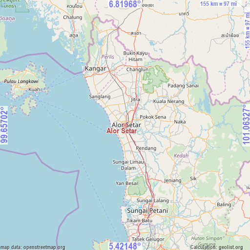
Alor Setar GPS coordinates[2]
6° 7' 15.744" North, 100° 21' 36.504" East
| Map corner | latitude | longitude |
|---|---|---|
| Upper-left | 6.81968°, | 99.65702° |
| Center: | 6.12104°, | 100.36014° |
| Lower-right: | 5.42148°, | 101.06327° |
| Map W x H: | 155.5×155.5 km | = 96.6×96.6mi |
| max Lat: | 6.88732° ⇑9% North |
| Alor Setar: | 6.12104° |
| min Lat: | ⇓91% South 1.24722° |
| min Long | Alor Setar | max Long |
| 99.68252° | 100.36014° | 118.61119° |
| W 10.1%⇐ | ⇒89.9% E |
Elevation
Elevation of Alor Setar is 7 m = 23 ft, and this is 37.7 m = 124 ft below average elevation for this country.
| Max E: |
1488 m = 4882 ft | 82% |
| Avg. | 44.7 m = 147 ft | |
| Alor Setar | 7 m = 23 ft | |
Min E: |
0 m = 0 ft | 18% |
See also: Alor Setar elevation on elevation.city.
Geographical zone
Alor Setar is located in North Torrid zone (between Equator and Tropic of Cancer). Distance of Equator is 680.6 km =422.9 mi to South.| Distance of | km | miles | from Alor Setar |
|---|---|---|---|
| North Pole | 9326.5 | 5795.2 | to North |
| Arctic Circle | 6720.6 | 4176 | to North |
| Tropic Cancer | 1925.3 | 1196.3 | to North |
| Equator | 680.6 | 422.9 | to South |


Nearby cities:
15 places around Alor Setar: (largest is in red/bold)
• Ayer Hangat
68.2 km =42.4 mi,  299°
299°
• Bedong
46.8 km =29.1 mi,  159°
159°
• Gurun
36 km =22.4 mi, 159°
• Jitra
17.7 km =11 mi,  22°
22°
• Kampung Bukit Hantu
69.2 km =43 mi,  292°
292°
• Kampung Kilim
64.6 km =40.1 mi, 299°
• Kangar
39.8 km =24.7 mi,  333°
333°
• Kepala Batas
67.6 km =42 mi,  173°
173°
• Kuah
61.5 km =38.2 mi, 291°
• Kuala Kedah
7 km =4.3 mi,  250°
250°
• Kuala Perlis
39.9 km =24.8 mi,  321°
321°
• Pantai Cenang
72.5 km =45 mi, 285°
• Sungai Petani
54.6 km =33.9 mi, 165°
• Tanjung Rhu
70.1 km =43.6 mi, 301°
• Tasek Glugor
72.9 km =45.3 mi, 167°
Sources, notices
• [Note1] Compared only with cities in Malaysia existing in our database
• [Src1] Map data: © OpenStreetMap contributors (CC-BY-SA)
• [Src2] Other city data from geonames.org with taken over terms of usage.
• [Src3] Geographical zone / Annual Mean Temperature by Robert A. Rohde @ Wikipedia
