Kuah geodata
Kuah (Kedah) is a seat of a second-order administrative division; located in Malaysia in Asia/Kuala_Lumpur (GMT+8) time zone. With population of 30,212 people, there are 87 cities with bigger population in this country. Compared to other cities in Malaysia, 93.8% of cities are located further ↓South; 96.1% of cities are located further →East and 60.1% of cities have higher elevation than Kuah. Note1


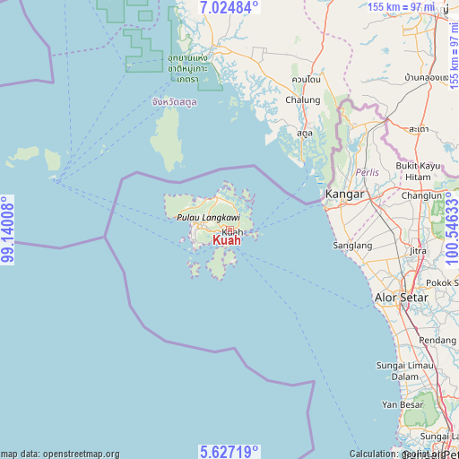
Kuah GPS coordinates[2]
6° 19' 35.364" North, 99° 50' 35.52" East
| Map corner | latitude | longitude |
|---|---|---|
| Upper-left | 7.02484°, | 99.14008° |
| Center: | 6.32649°, | 99.8432° |
| Lower-right: | 5.62719°, | 100.54633° |
| Map W x H: | 155.4×155.4 km | = 96.6×96.6mi |
| max Lat: | 6.88732° ⇑6.2% North |
| Kuah: | 6.32649° |
| min Lat: | ⇓93.8% South 1.24722° |
| min Long | Kuah | max Long |
| 99.68252° | 99.8432° | 118.61119° |
| W 3.9%⇐ | ⇒96.1% E |
Elevation
Elevation of Kuah is 11 m = 36 ft, and this is 33.7 m = 111 ft below average elevation for this country.
| Max E: |
1488 m = 4882 ft | 60.1% |
| Avg. | 44.7 m = 147 ft | |
| Kuah | 11 m = 36 ft | |
Min E: |
0 m = 0 ft | 39.9% |
See also: Malaysia elevation on elevation.city.
Geographical zone
Kuah is located in North Torrid zone (between Equator and Tropic of Cancer). Distance of Equator is 703.4 km =437.1 mi to South.| Distance of | km | miles | from Kuah |
|---|---|---|---|
| North Pole | 9303.6 | 5781 | to North |
| Arctic Circle | 6697.7 | 4161.8 | to North |
| Tropic Cancer | 1902.5 | 1182.2 | to North |
| Equator | 703.4 | 437.1 | to South |


Nearby cities:
15 places around Kuah: (largest is in red/bold)
• Alor Setar
61.5 km =38.2 mi,  111°
111°
• Ayer Hangat
10.7 km =6.6 mi,  347°
347°
• Bedong
99.3 km =61.7 mi,  132°
132°
• Gurun
89.8 km =55.8 mi, 129°
• Jitra
64.3 km =40 mi,  95°
95°
• Kampung Bukit Hantu
7.7 km =4.8 mi,  301°
301°
• Kampung Kilim
8.8 km =5.5 mi,  5°
5°
• Kampung Kok
18.3 km =11.4 mi,  284°
284°
• Kangar
41.3 km =25.7 mi,  71°
71°
• Kuala Kedah
56.4 km =35 mi,  116°
116°
• Kuala Perlis
33.1 km =20.6 mi,  75°
75°
• Kuala Teriang
14.7 km =9.1 mi,  286°
286°
• Padang Mat Sirat
12.5 km =7.8 mi, 284°
• Pantai Cenang
13.3 km =8.3 mi,  254°
254°
• Tanjung Rhu
14.2 km =8.8 mi, 349°
Sources, notices
• [Note1] Compared only with cities in Malaysia existing in our database
• [Src1] Map data: © OpenStreetMap contributors (CC-BY-SA)
• [Src2] Other city data from geonames.org with taken over terms of usage.
• [Src3] Geographical zone / Annual Mean Temperature by Robert A. Rohde @ Wikipedia
