Yenagoa geodata
Yenagoa (Bayelsa) is a seat of a first-order administrative division; located in Nigeria in Africa/Lagos (GMT+1) time zone. With population of 24,335 people, there are 180 cities with bigger population in this country. Compared to other cities in Nigeria, 94.8% of cities are located further ↑North; 66.9% of cities are located further →East and 97.1% of cities have higher elevation than Yenagoa. Note1


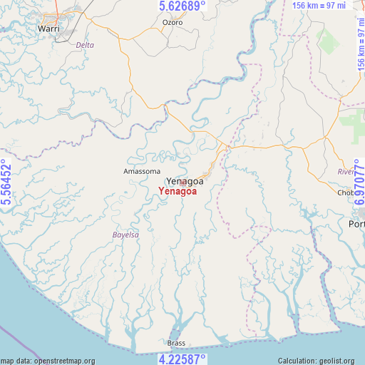
Yenagoa GPS coordinates[2]
4° 55' 36.3" North, 6° 16' 3.504" East
| Map corner | latitude | longitude |
|---|---|---|
| Upper-left | 5.62689°, | 5.56452° |
| Center: | 4.92675°, | 6.26764° |
| Lower-right: | 4.22587°, | 6.97077° |
| Map W x H: | 155.8×155.8 km | = 96.8×96.8mi |
| max Lat: | 13.7543° ⇑94.8% North |
| Yenagoa: | 4.92675° |
| min Lat: | ⇓5.2% South 4.31231° |
| min Long | Yenagoa | max Long |
| 2.73333° | 6.26764° | 14.46552° |
| W 33.1%⇐ | ⇒66.9% E |
Elevation
Elevation of Yenagoa is 8 m = 26 ft, and this is 288.5 m = 947 ft below average elevation for this country.
| Max E: |
1599 m = 5246 ft | 97.1% |
| Avg. | 296.5 m = 973 ft | |
| Yenagoa | 8 m = 26 ft | |
Min E: |
2 m = 7 ft | 2.9% |
See also: Nigeria elevation on elevation.city.
Geographical zone
Yenagoa is located in North Torrid zone (between Equator and Tropic of Cancer). Distance of Equator is 547.8 km =340.4 mi to South.| Distance of | km | miles | from Yenagoa |
|---|---|---|---|
| North Pole | 9459.3 | 5877.7 | to North |
| Arctic Circle | 6853.4 | 4258.5 | to North |
| Tropic Cancer | 2058.1 | 1278.8 | to North |
| Equator | 547.8 | 340.4 | to South |


Nearby cities:
15 places around Yenagoa: (largest is in red/bold)
• Abua
42.5 km =26.4 mi,  100°
100°
• Ahoada
45.7 km =28.4 mi,  67°
67°
• Akinima
28.2 km =17.5 mi,  51°
51°
• Amassoma
18.2 km =11.3 mi,  285°
285°
• Bomadi
46.1 km =28.6 mi,  304°
304°
• Degema
58.7 km =36.5 mi,  109°
109°
• Degema Hulk
56.5 km =35.1 mi, 108°
• Ekeremor
55.9 km =34.7 mi, 285°
• Kaiama
21.8 km =13.5 mi,  9°
9°
• Nembe
45.9 km =28.5 mi,  160°
160°
• Ogbia
27 km =16.8 mi,  168°
168°
• Oleh
59.9 km =37.2 mi,  353°
353°
• Oporoma
24.7 km =15.3 mi,  237°
237°
• Patani
34.6 km =21.5 mi, 345°
• Sagbama
27 km =16.8 mi,  343°
343°
Sources, notices
• [Note1] Compared only with cities in Nigeria existing in our database
• [Src1] Map data: © OpenStreetMap contributors (CC-BY-SA)
• [Src2] Other city data from geonames.org with taken over terms of usage.
• [Src3] Geographical zone / Annual Mean Temperature by Robert A. Rohde @ Wikipedia
