Amassoma geodata
Amassoma (Bayelsa) is a populated place; located in Nigeria in Africa/Lagos (GMT+1) time zone. With population of 6,970 people, there are 417 cities with bigger population in this country. Compared to other cities in Nigeria, 94.6% of cities are located further ↑North; 69.3% of cities are located further →East and 95.5% of cities have higher elevation than Amassoma. Note1


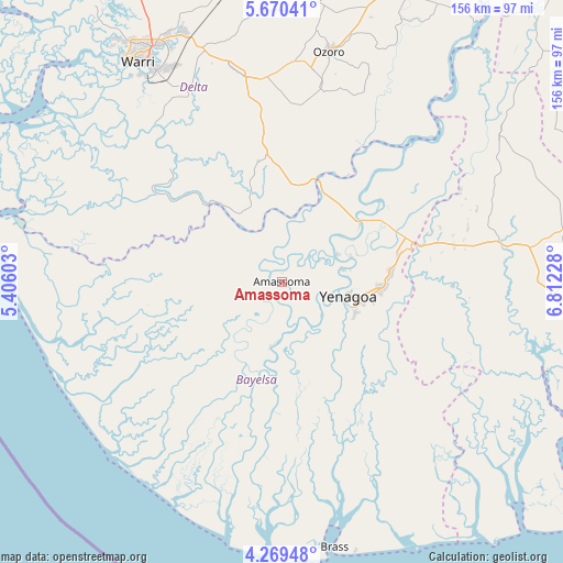
Amassoma GPS coordinates[2]
4° 58' 13.152" North, 6° 6' 32.94" East
| Map corner | latitude | longitude |
|---|---|---|
| Upper-left | 5.67041°, | 5.40603° |
| Center: | 4.97032°, | 6.10915° |
| Lower-right: | 4.26948°, | 6.81228° |
| Map W x H: | 155.8×155.8 km | = 96.8×96.8mi |
| max Lat: | 13.7543° ⇑94.6% North |
| Amassoma: | 4.97032° |
| min Lat: | ⇓5.4% South 4.31231° |
| min Long | Amassoma | max Long |
| 2.73333° | 6.10915° | 14.46552° |
| W 30.7%⇐ | ⇒69.3% E |
Elevation
Elevation of Amassoma is 11 m = 36 ft, and this is 285.5 m = 937 ft below average elevation for this country.
| Max E: |
1599 m = 5246 ft | 95.5% |
| Avg. | 296.5 m = 973 ft | |
| Amassoma | 11 m = 36 ft | |
Min E: |
2 m = 7 ft | 4.5% |
See also: Nigeria elevation on elevation.city.
Geographical zone
Amassoma is located in North Torrid zone (between Equator and Tropic of Cancer). Distance of Equator is 552.6 km =343.4 mi to South.| Distance of | km | miles | from Amassoma |
|---|---|---|---|
| North Pole | 9454.4 | 5874.7 | to North |
| Arctic Circle | 6848.5 | 4255.5 | to North |
| Tropic Cancer | 2053.3 | 1275.9 | to North |
| Equator | 552.6 | 343.4 | to South |


Nearby cities:
15 places around Amassoma: (largest is in red/bold)
• Abua
60.7 km =37.7 mi,  101°
101°
• Akinima
41.6 km =25.8 mi,  72°
72°
• Bomadi
29.5 km =18.3 mi,  315°
315°
• Ekeremor
37.7 km =23.4 mi,  285°
285°
• Kaiama
27 km =16.8 mi,  51°
51°
• Nembe
58.2 km =36.2 mi,  145°
145°
• Ogbia
38.8 km =24.1 mi,  143°
143°
• Oleh
55.7 km =34.6 mi,  11°
11°
• Oporoma
18.5 km =11.5 mi,  189°
189°
• Otor-Udu
59.9 km =37.2 mi,  333°
333°
• Otu-Jeremi
58 km =36 mi, 333°
• Patani
30.2 km =18.8 mi,  17°
17°
• Sagbama
23.1 km =14.4 mi, 24°
• Ughelli
58.9 km =36.6 mi,  348°
348°
• Yenagoa
18.2 km =11.3 mi,  105°
105°
Sources, notices
• [Note1] Compared only with cities in Nigeria existing in our database
• [Src1] Map data: © OpenStreetMap contributors (CC-BY-SA)
• [Src2] Other city data from geonames.org with taken over terms of usage.
• [Src3] Geographical zone / Annual Mean Temperature by Robert A. Rohde @ Wikipedia
