Ahoada geodata
Ahoada (Rivers) is a seat of a second-order administrative division; located in Nigeria in Africa/Lagos (GMT+1) time zone. With population of 12,848 people, there are 277 cities with bigger population in this country. Compared to other cities in Nigeria, 93.7% of cities are located further ↑North; 63% of cities are located further →East and 94.7% of cities have higher elevation than Ahoada. Note1


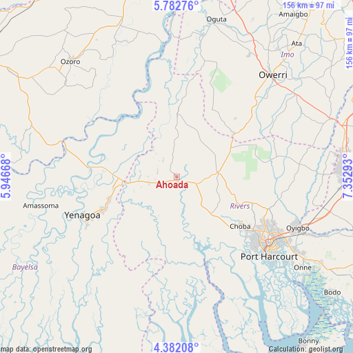
Ahoada GPS coordinates[2]
5° 4' 58.08" North, 6° 38' 59.316" East
| Map corner | latitude | longitude |
|---|---|---|
| Upper-left | 5.78276°, | 5.94668° |
| Center: | 5.0828°, | 6.64981° |
| Lower-right: | 4.38208°, | 7.35293° |
| Map W x H: | 155.7×155.7 km | = 96.7×96.7mi |
| max Lat: | 13.7543° ⇑93.7% North |
| Ahoada: | 5.0828° |
| min Lat: | ⇓6.3% South 4.31231° |
| min Long | Ahoada | max Long |
| 2.73333° | 6.64981° | 14.46552° |
| W 37%⇐ | ⇒63% E |
Elevation
Elevation of Ahoada is 13 m = 43 ft, and this is 283.5 m = 930 ft below average elevation for this country.
| Max E: |
1599 m = 5246 ft | 94.7% |
| Avg. | 296.5 m = 973 ft | |
| Ahoada | 13 m = 43 ft | |
Min E: |
2 m = 7 ft | 5.3% |
See also: Nigeria elevation on elevation.city.
Geographical zone
Ahoada is located in North Torrid zone (between Equator and Tropic of Cancer). Distance of Equator is 565.2 km =351.2 mi to South.| Distance of | km | miles | from Ahoada |
|---|---|---|---|
| North Pole | 9441.9 | 5866.9 | to North |
| Arctic Circle | 6836 | 4247.7 | to North |
| Tropic Cancer | 2040.8 | 1268.1 | to North |
| Equator | 565.2 | 351.2 | to South |


Nearby cities:
15 places around Ahoada: (largest is in red/bold)
• Abonnema
41.3 km =25.7 mi,  160°
160°
• Abua
25 km =15.5 mi,  181°
181°
• Akinima
20.3 km =12.6 mi,  270°
270°
• Buguma
45.2 km =28.1 mi,  148°
148°
• Degema
39.4 km =24.5 mi, 160°
• Degema Hulk
37.4 km =23.2 mi, 162°
• Elele
18.3 km =11.4 mi,  83°
83°
• Emuoha
32.1 km =19.9 mi,  133°
133°
• Isiokpo
26.2 km =16.3 mi,  109°
109°
• Kaiama
38.8 km =24.1 mi,  276°
276°
• Obonoma
44.2 km =27.5 mi, 159°
• Omoku
29 km =18 mi,  1°
1°
• Rumuodomaya
44.4 km =27.6 mi,  118°
118°
• Sagbama
50.9 km =31.6 mi, 279°
• Yenagoa
45.7 km =28.4 mi,  247°
247°
Sources, notices
• [Note1] Compared only with cities in Nigeria existing in our database
• [Src1] Map data: © OpenStreetMap contributors (CC-BY-SA)
• [Src2] Other city data from geonames.org with taken over terms of usage.
• [Src3] Geographical zone / Annual Mean Temperature by Robert A. Rohde @ Wikipedia
