Ogbia geodata
Ogbia (Bayelsa) is a seat of a second-order administrative division; located in Nigeria in Africa/Lagos (GMT+1) time zone. In our database, there are 451 cities with bigger population. Compared to other cities in Nigeria, 98.5% of cities are located further ↑North; 66.4% of cities are located further →East and 97.1% of cities have higher elevation than Ogbia. Note1


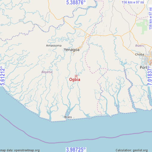
Ogbia GPS coordinates[2]
4° 41' 18.096" North, 6° 18' 54.9" East
| Map corner | latitude | longitude |
|---|---|---|
| Upper-left | 5.38876°, | 5.61212° |
| Center: | 4.68836°, | 6.31525° |
| Lower-right: | 3.98725°, | 7.01837° |
| Map W x H: | 155.8×155.8 km | = 96.8×96.8mi |
| max Lat: | 13.7543° ⇑98.5% North |
| Ogbia: | 4.68836° |
| min Lat: | ⇓1.5% South 4.31231° |
| min Long | Ogbia | max Long |
| 2.73333° | 6.31525° | 14.46552° |
| W 33.6%⇐ | ⇒66.4% E |
Elevation
Elevation of Ogbia is 8 m = 26 ft, and this is 288.5 m = 947 ft below average elevation for this country.
| Max E: |
1599 m = 5246 ft | 97.1% |
| Avg. | 296.5 m = 973 ft | |
| Ogbia | 8 m = 26 ft | |
Min E: |
2 m = 7 ft | 2.9% |
See also: Nigeria elevation on elevation.city.
Geographical zone
Ogbia is located in North Torrid zone (between Equator and Tropic of Cancer). Distance of Equator is 521.3 km =323.9 mi to South.| Distance of | km | miles | from Ogbia |
|---|---|---|---|
| North Pole | 9485.8 | 5894.2 | to North |
| Arctic Circle | 6879.9 | 4275 | to North |
| Tropic Cancer | 2084.6 | 1295.3 | to North |
| Equator | 521.3 | 323.9 | to South |


Nearby cities:
15 places around Ogbia: (largest is in red/bold)
• Abonnema
50.9 km =31.6 mi,  84°
84°
• Abua
41.1 km =25.5 mi,  62°
62°
• Ahoada
57.4 km =35.7 mi,  40°
40°
• Akinima
47.2 km =29.3 mi,  20°
20°
• Amassoma
38.8 km =24.1 mi,  323°
323°
• Buguma
60.9 km =37.8 mi, 84°
• Degema
50.4 km =31.3 mi, 82°
• Degema Hulk
48.8 km =30.3 mi, 80°
• Kaiama
48 km =29.8 mi,  358°
358°
• Nembe
19.5 km =12.1 mi,  149°
149°
• Obonoma
52.8 km =32.8 mi,  87°
87°
• Oporoma
29.2 km =18.1 mi,  296°
296°
• Sagbama
54 km =33.6 mi,  345°
345°
• Twon-Brass
42.6 km =26.5 mi,  191°
191°
• Yenagoa
27 km =16.8 mi, 348°
Sources, notices
• [Note1] Compared only with cities in Nigeria existing in our database
• [Src1] Map data: © OpenStreetMap contributors (CC-BY-SA)
• [Src2] Other city data from geonames.org with taken over terms of usage.
• [Src3] Geographical zone / Annual Mean Temperature by Robert A. Rohde @ Wikipedia
