Tokombere geodata
Tokombere (Borno) is a populated place; located in Nigeria in Africa/Lagos (GMT+1) time zone. With population of 7,092 people, there are 414 cities with bigger population in this country. Compared to other cities in Nigeria, 74.1% of cities are located further ↓South; 98.8% of cities are located further ←West and 63.2% of cities have lower elevation than Tokombere. Note1


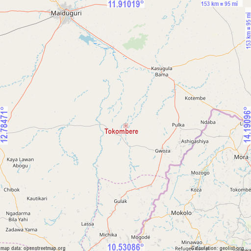
Tokombere GPS coordinates[2]
11° 13' 16.86" North, 13° 29' 16.188" East
| Map corner | latitude | longitude |
|---|---|---|
| Upper-left | 11.91019°, | 12.78471° |
| Center: | 11.22135°, | 13.48783° |
| Lower-right: | 10.53086°, | 14.19096° |
| Map W x H: | 153.4×153.4 km | = 95.3×95.3mi |
| max Lat: | 13.7543° ⇑25.9% North |
| Tokombere: | 11.22135° |
| min Lat: | ⇓74.1% South 4.31231° |
| min Long | Tokombere | max Long |
| 2.73333° | 13.48783° | 14.46552° |
| W 98.8%⇐ | ⇒1.2% E |
Elevation
Elevation of Tokombere is 360 m = 1181 ft, and this is 63.5 m = 208 ft above average elevation for this country.
| Max E: |
1599 m = 5246 ft | 36.8% |
| Tokombere | 360 m 1181 ft | |
| Avg. | 296.5 m = 973 ft | |
Min E: |
2 m = 7 ft | 63.2% |
See also: Nigeria elevation on elevation.city.
Geographical zone
Tokombere is located in North Torrid zone (between Equator and Tropic of Cancer). Distance of Equator is 1247.7 km =775.3 mi to South.| Distance of | km | miles | from Tokombere |
|---|---|---|---|
| North Pole | 8759.4 | 5442.8 | to North |
| Arctic Circle | 6153.5 | 3823.6 | to North |
| Tropic Cancer | 1358.2 | 843.9 | to North |
| Equator | 1247.7 | 775.3 | to South |


Nearby cities:
15 places around Tokombere: (largest is in red/bold)
• Askira
89.5 km =55.6 mi,  224°
224°
• Bama
39.9 km =24.8 mi,  33°
33°
• Chibok
80.2 km =49.8 mi,  240°
240°
• Damboa
80.1 km =49.8 mi,  264°
264°
• Dikwa
102 km =63.4 mi, 27°
• Gulak
46.4 km =28.8 mi,  183°
183°
• Gwoza
27.4 km =17 mi,  124°
124°
• Khaddamari
83.2 km =51.7 mi,  340°
340°
• Konduga
48.6 km =30.2 mi,  350°
350°
• Madagali
40 km =24.9 mi,  157°
157°
• Mafa
79.1 km =49.2 mi,  8°
8°
• Maiduguri
78.3 km =48.7 mi,  332°
332°
• Michika
67.7 km =42.1 mi,  189°
189°
• Uba
90 km =55.9 mi,  198°
198°
• Yajiwa
85.7 km =53.3 mi,  282°
282°
Sources, notices
• [Note1] Compared only with cities in Nigeria existing in our database
• [Src1] Map data: © OpenStreetMap contributors (CC-BY-SA)
• [Src2] Other city data from geonames.org with taken over terms of usage.
• [Src3] Geographical zone / Annual Mean Temperature by Robert A. Rohde @ Wikipedia
