Konduga geodata
Konduga (Borno) is a seat of a second-order administrative division; located in Nigeria in Africa/Lagos (GMT+1) time zone. With population of 13,400 people, there are 266 cities with bigger population in this country. Compared to other cities in Nigeria, 79.4% of cities are located further ↓South; 98.6% of cities are located further ←West and 57.7% of cities have lower elevation than Konduga. Note1


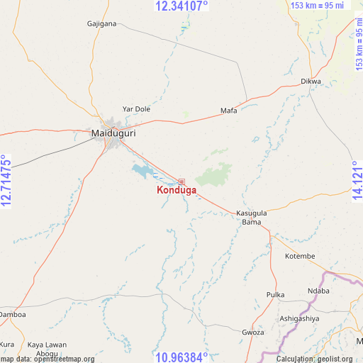
Konduga GPS coordinates[2]
11° 39' 11.916" North, 13° 25' 4.332" East
| Map corner | latitude | longitude |
|---|---|---|
| Upper-left | 12.34107°, | 12.71475° |
| Center: | 11.65331°, | 13.41787° |
| Lower-right: | 10.96384°, | 14.121° |
| Map W x H: | 153.1×153.1 km | = 95.1×95.1mi |
| max Lat: | 13.7543° ⇑20.6% North |
| Konduga: | 11.65331° |
| min Lat: | ⇓79.4% South 4.31231° |
| min Long | Konduga | max Long |
| 2.73333° | 13.41787° | 14.46552° |
| W 98.6%⇐ | ⇒1.4% E |
Elevation
Elevation of Konduga is 330 m = 1083 ft, and this is 33.5 m = 110 ft above average elevation for this country.
| Max E: |
1599 m = 5246 ft | 42.3% |
| Konduga | 330 m 1083 ft | |
| Avg. | 296.5 m = 973 ft | |
Min E: |
2 m = 7 ft | 57.7% |
See also: Nigeria elevation on elevation.city.
Geographical zone
Konduga is located in North Torrid zone (between Equator and Tropic of Cancer). Distance of Equator is 1295.7 km =805.1 mi to South.| Distance of | km | miles | from Konduga |
|---|---|---|---|
| North Pole | 8711.3 | 5412.9 | to North |
| Arctic Circle | 6105.4 | 3793.7 | to North |
| Tropic Cancer | 1310.2 | 814.1 | to North |
| Equator | 1295.7 | 805.1 | to South |


Nearby cities:
15 places around Konduga: (largest is in red/bold)
• Bama
33 km =20.5 mi,  116°
116°
• Benisheikh
102.3 km =63.6 mi,  279°
279°
• Damboa
90.9 km =56.5 mi,  232°
232°
• Dikwa
69.1 km =42.9 mi,  51°
51°
• Gajiram
95.8 km =59.5 mi,  346°
346°
• Gulak
94.4 km =58.7 mi,  177°
177°
• Gwoza
70.3 km =43.7 mi,  154°
154°
• Khaddamari
36.5 km =22.7 mi,  326°
326°
• Madagali
88 km =54.7 mi,  164°
164°
• Mafa
36.1 km =22.4 mi,  33°
33°
• Magumeri
82.3 km =51.1 mi,  308°
308°
• Maiduguri
35.6 km =22.1 mi, 307°
• Marte
90.9 km =56.5 mi, 29°
• Tokombere
48.6 km =30.2 mi,  170°
170°
• Yajiwa
81.6 km =50.7 mi,  248°
248°
Sources, notices
• [Note1] Compared only with cities in Nigeria existing in our database
• [Src1] Map data: © OpenStreetMap contributors (CC-BY-SA)
• [Src2] Other city data from geonames.org with taken over terms of usage.
• [Src3] Geographical zone / Annual Mean Temperature by Robert A. Rohde @ Wikipedia
