Gwoza geodata
Gwoza (Borno) is a seat of a second-order administrative division; located in Nigeria in Africa/Lagos (GMT+1) time zone. With population of 15,176 people, there are 239 cities with bigger population in this country. Compared to other cities in Nigeria, 73% of cities are located further ↓South; 99.4% of cities are located further ←West and 73.1% of cities have lower elevation than Gwoza. Note1


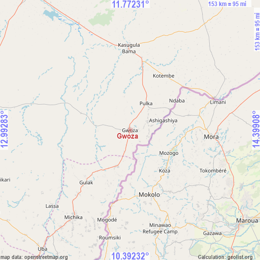
Gwoza GPS coordinates[2]
11° 4' 59.268" North, 13° 41' 45.42" East
| Map corner | latitude | longitude |
|---|---|---|
| Upper-left | 11.77231°, | 12.99283° |
| Center: | 11.08313°, | 13.69595° |
| Lower-right: | 10.39232°, | 14.39908° |
| Map W x H: | 153.4×153.4 km | = 95.3×95.3mi |
| max Lat: | 13.7543° ⇑27% North |
| Gwoza: | 11.08313° |
| min Lat: | ⇓73% South 4.31231° |
| min Long | Gwoza | max Long |
| 2.73333° | 13.69595° | 14.46552° |
| W 99.4%⇐ | ⇒0.59999999999999% E |
Elevation
Elevation of Gwoza is 418 m = 1371 ft, and this is 121.5 m = 399 ft above average elevation for this country.
| Max E: |
1599 m = 5246 ft | 26.9% |
| Gwoza | 418 m 1371 ft | |
| Avg. | 296.5 m = 973 ft | |
Min E: |
2 m = 7 ft | 73.1% |
See also: Nigeria elevation on elevation.city.
Geographical zone
Gwoza is located in North Torrid zone (between Equator and Tropic of Cancer). Distance of Equator is 1232.3 km =765.7 mi to South.| Distance of | km | miles | from Gwoza |
|---|---|---|---|
| North Pole | 8774.7 | 5452.3 | to North |
| Arctic Circle | 6168.8 | 3833.1 | to North |
| Tropic Cancer | 1373.6 | 853.5 | to North |
| Equator | 1232.3 | 765.7 | to South |


Nearby cities:
15 places around Gwoza: (largest is in red/bold)
• Askira
98.5 km =61.2 mi,  240°
240°
• Bama
48.7 km =30.3 mi,  359°
359°
• Chibok
95.7 km =59.5 mi,  255°
255°
• Damboa
102.8 km =63.9 mi,  274°
274°
• Dikwa
108.7 km =67.5 mi,  12°
12°
• Gulak
40.3 km =25 mi,  220°
220°
• Khaddamari
106.5 km =66.2 mi,  331°
331°
• Konduga
70.3 km =43.7 mi, 334°
• Madagali
22.8 km =14.2 mi,  198°
198°
• Mafa
94.1 km =58.5 mi,  353°
353°
• Maiduguri
103.2 km =64.1 mi, 325°
• Michika
61.4 km =38.2 mi,  213°
213°
• Mubi
102 km =63.4 mi, 207°
• Tokombere
27.4 km =17 mi,  304°
304°
• Uba
86.9 km =54 mi, 216°
Sources, notices
• [Note1] Compared only with cities in Nigeria existing in our database
• [Src1] Map data: © OpenStreetMap contributors (CC-BY-SA)
• [Src2] Other city data from geonames.org with taken over terms of usage.
• [Src3] Geographical zone / Annual Mean Temperature by Robert A. Rohde @ Wikipedia
