Siluko geodata
Siluko (Edo) is a populated place; located in Nigeria in Africa/Lagos (GMT+1) time zone. With population of 7,920 people, there are 386 cities with bigger population in this country. Compared to other cities in Nigeria, 75.9% of cities are located further ↑North; 79.1% of cities are located further →East and 86.9% of cities have higher elevation than Siluko. Note1


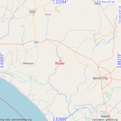
Siluko GPS coordinates[2]
6° 32' 9.204" North, 5° 9' 36.18" East
| Map corner | latitude | longitude |
|---|---|---|
| Upper-left | 7.23394°, | 4.45693° |
| Center: | 6.53589°, | 5.16005° |
| Lower-right: | 5.83686°, | 5.86318° |
| Map W x H: | 155.3×155.3 km | = 96.5×96.5mi |
| max Lat: | 13.7543° ⇑75.9% North |
| Siluko: | 6.53589° |
| min Lat: | ⇓24.1% South 4.31231° |
| min Long | Siluko | max Long |
| 2.73333° | 5.16005° | 14.46552° |
| W 20.9%⇐ | ⇒79.1% E |
Elevation
Elevation of Siluko is 51 m = 167 ft, and this is 245.5 m = 805 ft below average elevation for this country.
| Max E: |
1599 m = 5246 ft | 86.9% |
| Avg. | 296.5 m = 973 ft | |
| Siluko | 51 m = 167 ft | |
Min E: |
2 m = 7 ft | 13.1% |
See also: Nigeria elevation on elevation.city.
Geographical zone
Siluko is located in North Torrid zone (between Equator and Tropic of Cancer). Distance of Equator is 726.7 km =451.6 mi to South.| Distance of | km | miles | from Siluko |
|---|---|---|---|
| North Pole | 9280.3 | 5766.5 | to North |
| Arctic Circle | 6674.5 | 4147.3 | to North |
| Tropic Cancer | 1879.2 | 1167.7 | to North |
| Equator | 726.7 | 451.6 | to South |


Nearby cities:
15 places around Siluko: (largest is in red/bold)
• Agbabu
36.5 km =22.7 mi,  279°
279°
• Benin City
56 km =34.8 mi,  113°
113°
• Bolorunduro
73.3 km =45.5 mi,  342°
342°
• Idanre
64.3 km =40 mi,  355°
355°
• Idogbo
68 km =42.3 mi,  115°
115°
• Igbekebo
38.6 km =24 mi,  238°
238°
• Igbokoda
44.3 km =27.5 mi, 242°
• Iguobazuwa
21.7 km =13.5 mi,  81°
81°
• Koko
67.9 km =42.2 mi,  151°
151°
• Ode-Irele
32.3 km =20.1 mi,  261°
261°
• Okada
34.1 km =21.2 mi,  49°
49°
• Ondo
71.6 km =44.5 mi,  329°
329°
• Ore
39.2 km =24.4 mi,  306°
306°
• Owena
74.7 km =46.4 mi,  348°
348°
• Uselu
52.5 km =32.6 mi, 108°
Sources, notices
• [Note1] Compared only with cities in Nigeria existing in our database
• [Src1] Map data: © OpenStreetMap contributors (CC-BY-SA)
• [Src2] Other city data from geonames.org with taken over terms of usage.
• [Src3] Geographical zone / Annual Mean Temperature by Robert A. Rohde @ Wikipedia
