Uselu geodata
Uselu (Edo) is a seat of a second-order administrative division; located in Nigeria in Africa/Lagos (GMT+1) time zone. In our database, there are 451 cities with bigger population. Compared to other cities in Nigeria, 78.7% of cities are located further ↑North; 74.6% of cities are located further →East and 76.2% of cities have higher elevation than Uselu. Note1


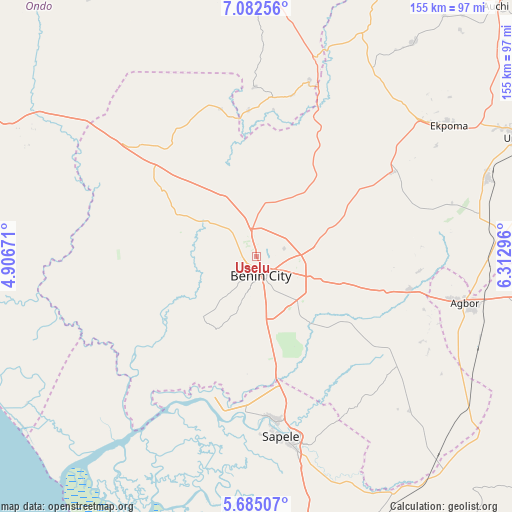
Uselu GPS coordinates[2]
6° 23' 3.444" North, 5° 36' 35.424" East
| Map corner | latitude | longitude |
|---|---|---|
| Upper-left | 7.08256°, | 4.90671° |
| Center: | 6.38429°, | 5.60984° |
| Lower-right: | 5.68507°, | 6.31296° |
| Map W x H: | 155.4×155.4 km | = 96.6×96.6mi |
| max Lat: | 13.7543° ⇑78.7% North |
| Uselu: | 6.38429° |
| min Lat: | ⇓21.3% South 4.31231° |
| min Long | Uselu | max Long |
| 2.73333° | 5.60984° | 14.46552° |
| W 25.4%⇐ | ⇒74.6% E |
Elevation
Elevation of Uselu is 110 m = 361 ft, and this is 186.5 m = 612 ft below average elevation for this country.
| Max E: |
1599 m = 5246 ft | 76.2% |
| Avg. | 296.5 m = 973 ft | |
| Uselu | 110 m = 361 ft | |
Min E: |
2 m = 7 ft | 23.8% |
See also: Nigeria elevation on elevation.city.
Geographical zone
Uselu is located in North Torrid zone (between Equator and Tropic of Cancer). Distance of Equator is 709.9 km =441.1 mi to South.| Distance of | km | miles | from Uselu |
|---|---|---|---|
| North Pole | 9297.2 | 5777 | to North |
| Arctic Circle | 6691.3 | 4157.8 | to North |
| Tropic Cancer | 1896.1 | 1178.2 | to North |
| Equator | 709.9 | 441.1 | to South |


Nearby cities:
15 places around Uselu: (largest is in red/bold)
• Abudu
47.5 km =29.5 mi,  102°
102°
• Agbor
66.2 km =41.1 mi, 102°
• Benin City
5.4 km =3.4 mi,  161°
161°
• Ehor
48.5 km =30.1 mi,  58°
58°
• Ekpoma
70.9 km =44.1 mi, 55°
• Idogbo
17.2 km =10.7 mi,  138°
138°
• Ifon
63.3 km =39.3 mi,  16°
16°
• Iguobazuwa
34.7 km =21.6 mi,  305°
305°
• Koko
45.9 km =28.5 mi,  201°
201°
• Oghara
50.3 km =31.3 mi,  172°
172°
• Okada
45.7 km =28.4 mi,  328°
328°
• Owa-Oyibu
68.9 km =42.8 mi,  108°
108°
• Sabongida-Ora
67.7 km =42.1 mi,  31°
31°
• Sapele
55 km =34.2 mi, 172°
• Siluko
52.5 km =32.6 mi,  288°
288°
Sources, notices
• [Note1] Compared only with cities in Nigeria existing in our database
• [Src1] Map data: © OpenStreetMap contributors (CC-BY-SA)
• [Src2] Other city data from geonames.org with taken over terms of usage.
• [Src3] Geographical zone / Annual Mean Temperature by Robert A. Rohde @ Wikipedia
