Agbabu geodata
Agbabu (Ondo) is a populated place; located in Nigeria in Africa/Lagos (GMT+1) time zone. With population of 8,611 people, there are 366 cities with bigger population in this country. Compared to other cities in Nigeria, 75% of cities are located further ↑North; 83.4% of cities are located further →East and 94.9% of cities have higher elevation than Agbabu. Note1


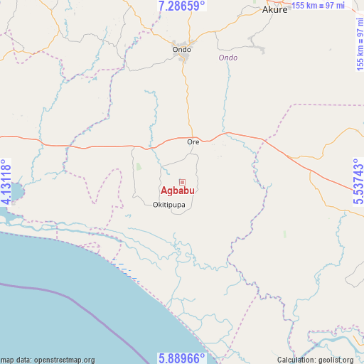
Agbabu GPS coordinates[2]
6° 35' 19.032" North, 4° 50' 3.48" East
| Map corner | latitude | longitude |
|---|---|---|
| Upper-left | 7.28659°, | 4.13118° |
| Center: | 6.58862°, | 4.8343° |
| Lower-right: | 5.88966°, | 5.53743° |
| Map W x H: | 155.3×155.3 km | = 96.5×96.5mi |
| max Lat: | 13.7543° ⇑75% North |
| Agbabu: | 6.58862° |
| min Lat: | ⇓25% South 4.31231° |
| min Long | Agbabu | max Long |
| 2.73333° | 4.8343° | 14.46552° |
| W 16.6%⇐ | ⇒83.4% E |
Elevation
Elevation of Agbabu is 12 m = 39 ft, and this is 284.5 m = 933 ft below average elevation for this country.
| Max E: |
1599 m = 5246 ft | 94.9% |
| Avg. | 296.5 m = 973 ft | |
| Agbabu | 12 m = 39 ft | |
Min E: |
2 m = 7 ft | 5.1% |
See also: Nigeria elevation on elevation.city.
Geographical zone
Agbabu is located in North Torrid zone (between Equator and Tropic of Cancer). Distance of Equator is 732.6 km =455.2 mi to South.| Distance of | km | miles | from Agbabu |
|---|---|---|---|
| North Pole | 9274.5 | 5762.9 | to North |
| Arctic Circle | 6668.6 | 4143.7 | to North |
| Tropic Cancer | 1873.3 | 1164 | to North |
| Equator | 732.6 | 455.2 | to South |


Nearby cities:
15 places around Agbabu: (largest is in red/bold)
• Abigi
49.8 km =30.9 mi,  256°
256°
• Bolorunduro
65.8 km =40.9 mi,  12°
12°
• Idanre
66 km =41 mi,  28°
28°
• Ifetedo
67.8 km =42.1 mi,  347°
347°
• Igbekebo
26.1 km =16.2 mi,  173°
173°
• Igbokoda
26.4 km =16.4 mi,  187°
187°
• Iguobazuwa
57.5 km =35.7 mi,  92°
92°
• Ile-Oluji
69.5 km =43.2 mi,  3°
3°
• Ode-Irele
11.2 km =7 mi,  159°
159°
• Ogbere
76.2 km =47.3 mi,  282°
282°
• Okada
64 km =39.8 mi,  75°
75°
• Ondo
56.1 km =34.9 mi, 0°
• Ore
18.2 km =11.3 mi, 14°
• Owena
70.5 km =43.8 mi,  17°
17°
• Siluko
36.5 km =22.7 mi,  99°
99°
Sources, notices
• [Note1] Compared only with cities in Nigeria existing in our database
• [Src1] Map data: © OpenStreetMap contributors (CC-BY-SA)
• [Src2] Other city data from geonames.org with taken over terms of usage.
• [Src3] Geographical zone / Annual Mean Temperature by Robert A. Rohde @ Wikipedia
