Iguobazuwa geodata
Iguobazuwa (Edo) is a seat of a second-order administrative division; located in Nigeria in Africa/Lagos (GMT+1) time zone. In our database, there are 451 cities with bigger population. Compared to other cities in Nigeria, 75.4% of cities are located further ↑North; 76.9% of cities are located further →East and 73.7% of cities have higher elevation than Iguobazuwa. Note1


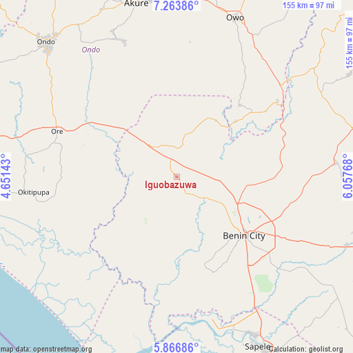
Iguobazuwa GPS coordinates[2]
6° 33' 57.06" North, 5° 21' 16.38" East
| Map corner | latitude | longitude |
|---|---|---|
| Upper-left | 7.26386°, | 4.65143° |
| Center: | 6.56585°, | 5.35455° |
| Lower-right: | 5.86686°, | 6.05768° |
| Map W x H: | 155.3×155.3 km | = 96.5×96.5mi |
| max Lat: | 13.7543° ⇑75.4% North |
| Iguobazuwa: | 6.56585° |
| min Lat: | ⇓24.6% South 4.31231° |
| min Long | Iguobazuwa | max Long |
| 2.73333° | 5.35455° | 14.46552° |
| W 23.1%⇐ | ⇒76.9% E |
Elevation
Elevation of Iguobazuwa is 128 m = 420 ft, and this is 168.5 m = 553 ft below average elevation for this country.
| Max E: |
1599 m = 5246 ft | 73.7% |
| Avg. | 296.5 m = 973 ft | |
| Iguobazuwa | 128 m = 420 ft | |
Min E: |
2 m = 7 ft | 26.3% |
See also: Nigeria elevation on elevation.city.
Geographical zone
Iguobazuwa is located in North Torrid zone (between Equator and Tropic of Cancer). Distance of Equator is 730.1 km =453.7 mi to South.| Distance of | km | miles | from Iguobazuwa |
|---|---|---|---|
| North Pole | 9277 | 5764.5 | to North |
| Arctic Circle | 6671.1 | 4145.2 | to North |
| Tropic Cancer | 1875.9 | 1165.6 | to North |
| Equator | 730.1 | 453.7 | to South |


Nearby cities:
15 places around Iguobazuwa: (largest is in red/bold)
• Agbabu
57.5 km =35.7 mi,  272°
272°
• Benin City
39.2 km =24.4 mi,  130°
130°
• Ehor
69.6 km =43.2 mi,  85°
85°
• Idanre
66.3 km =41.2 mi,  336°
336°
• Idogbo
51.6 km =32.1 mi, 129°
• Ifon
61.5 km =38.2 mi,  48°
48°
• Igbekebo
59.2 km =36.8 mi,  246°
246°
• Igbokoda
65.3 km =40.6 mi, 248°
• Koko
63.8 km =39.6 mi,  169°
169°
• Ode-Irele
54.1 km =33.6 mi,  261°
261°
• Okada
19.3 km =12 mi,  13°
13°
• Ore
56.6 km =35.2 mi,  290°
290°
• Sabongida-Ora
73.8 km =45.9 mi,  59°
59°
• Siluko
21.7 km =13.5 mi, 261°
• Uselu
34.7 km =21.6 mi, 125°
Sources, notices
• [Note1] Compared only with cities in Nigeria existing in our database
• [Src1] Map data: © OpenStreetMap contributors (CC-BY-SA)
• [Src2] Other city data from geonames.org with taken over terms of usage.
• [Src3] Geographical zone / Annual Mean Temperature by Robert A. Rohde @ Wikipedia
