Ogoja geodata
Ogoja (Cross River) is a seat of a second-order administrative division; located in Nigeria in Africa/Lagos (GMT+1) time zone. With population of 37,466 people, there are 156 cities with bigger population in this country. Compared to other cities in Nigeria, 73.5% of cities are located further ↑North; 75% of cities are located further ←West and 77.6% of cities have higher elevation than Ogoja. Note1


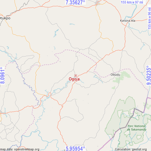
Ogoja GPS coordinates[2]
6° 39' 30.24" North, 8° 47' 57.228" East
| Map corner | latitude | longitude |
|---|---|---|
| Upper-left | 7.35627°, | 8.0961° |
| Center: | 6.6584°, | 8.79923° |
| Lower-right: | 5.95954°, | 9.50235° |
| Map W x H: | 155.3×155.3 km | = 96.5×96.5mi |
| max Lat: | 13.7543° ⇑73.5% North |
| Ogoja: | 6.6584° |
| min Lat: | ⇓26.5% South 4.31231° |
| min Long | Ogoja | max Long |
| 2.73333° | 8.79923° | 14.46552° |
| W 75%⇐ | ⇒25% E |
Elevation
Elevation of Ogoja is 96 m = 315 ft, and this is 200.5 m = 658 ft below average elevation for this country.
| Max E: |
1599 m = 5246 ft | 77.6% |
| Avg. | 296.5 m = 973 ft | |
| Ogoja | 96 m = 315 ft | |
Min E: |
2 m = 7 ft | 22.4% |
See also: Nigeria elevation on elevation.city.
Geographical zone
Ogoja is located in North Torrid zone (between Equator and Tropic of Cancer). Distance of Equator is 740.3 km =460 mi to South.| Distance of | km | miles | from Ogoja |
|---|---|---|---|
| North Pole | 9266.7 | 5758.1 | to North |
| Arctic Circle | 6660.8 | 4138.8 | to North |
| Tropic Cancer | 1865.6 | 1159.2 | to North |
| Equator | 740.3 | 460 | to South |


Nearby cities:
15 places around Ogoja: (largest is in red/bold)
• Abuochiche
16.3 km =10.1 mi,  77°
77°
• Adikpo
54.4 km =33.8 mi,  61°
61°
• Boje
43.7 km =27.2 mi,  162°
162°
• Gakem
24.5 km =15.2 mi, 59°
• Gboko
77.2 km =48 mi,  16°
16°
• Iboko
68.5 km =42.6 mi,  245°
245°
• Lessel
57.5 km =35.7 mi,  25°
25°
• Obarike-Ito
66.4 km =41.3 mi,  307°
307°
• Obudu
40.4 km =25.1 mi,  88°
88°
• Oju
46.8 km =29.1 mi,  296°
296°
• Okpoma
19.2 km =11.9 mi, 249°
• Sankwala
48.4 km =30.1 mi,  104°
104°
• Tse-Agberagba
48.8 km =30.3 mi,  342°
342°
• Ugbodo
75.7 km =47 mi,  257°
257°
• Vandeikya
32.8 km =20.4 mi, 64°
Sources, notices
• [Note1] Compared only with cities in Nigeria existing in our database
• [Src1] Map data: © OpenStreetMap contributors (CC-BY-SA)
• [Src2] Other city data from geonames.org with taken over terms of usage.
• [Src3] Geographical zone / Annual Mean Temperature by Robert A. Rohde @ Wikipedia
