Lessel geodata
Lessel (Benue) is a seat of a second-order administrative division; located in Nigeria in Africa/Lagos (GMT+1) time zone. In our database, there are 451 cities with bigger population. Compared to other cities in Nigeria, 67.1% of cities are located further ↑North; 76.9% of cities are located further ←West and 61.8% of cities have higher elevation than Lessel. Note1


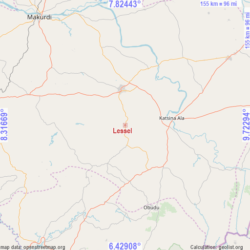
Lessel GPS coordinates[2]
7° 7' 38.244" North, 9° 1' 11.316" East
| Map corner | latitude | longitude |
|---|---|---|
| Upper-left | 7.82443°, | 8.31669° |
| Center: | 7.12729°, | 9.01981° |
| Lower-right: | 6.42908°, | 9.72294° |
| Map W x H: | 155.1×155.2 km | = 96.4×96.4mi |
| max Lat: | 13.7543° ⇑67.1% North |
| Lessel: | 7.12729° |
| min Lat: | ⇓32.9% South 4.31231° |
| min Long | Lessel | max Long |
| 2.73333° | 9.01981° | 14.46552° |
| W 76.9%⇐ | ⇒23.1% E |
Elevation
Elevation of Lessel is 194 m = 636 ft, and this is 102.5 m = 336 ft below average elevation for this country.
| Max E: |
1599 m = 5246 ft | 61.8% |
| Avg. | 296.5 m = 973 ft | |
| Lessel | 194 m = 636 ft | |
Min E: |
2 m = 7 ft | 38.2% |
See also: Nigeria elevation on elevation.city.
Geographical zone
Lessel is located in North Torrid zone (between Equator and Tropic of Cancer). Distance of Equator is 792.5 km =492.4 mi to South.| Distance of | km | miles | from Lessel |
|---|---|---|---|
| North Pole | 9214.6 | 5725.7 | to North |
| Arctic Circle | 6608.7 | 4106.5 | to North |
| Tropic Cancer | 1813.4 | 1126.8 | to North |
| Equator | 792.5 | 492.4 | to South |


Nearby cities:
15 places around Lessel: (largest is in red/bold)
• Abuochiche
49.2 km =30.6 mi,  189°
189°
• Adikpo
35.4 km =22 mi,  138°
138°
• Aliade
62.1 km =38.6 mi,  287°
287°
• Buruku
42.2 km =26.2 mi,  28°
28°
• Gakem
39.9 km =24.8 mi,  184°
184°
• Gboko
21.8 km =13.5 mi,  354°
354°
• Igbor
58 km =36 mi,  308°
308°
• Katsina-Ala
29.6 km =18.4 mi,  80°
80°
• Obudu
53.5 km =33.2 mi,  162°
162°
• Ogoja
57.5 km =35.7 mi,  205°
205°
• Tse-Agberagba
39.5 km =24.5 mi,  261°
261°
• Ugba
55.6 km =34.5 mi,  40°
40°
• Vandeikya
38.4 km =23.9 mi,  172°
172°
• Wannune
50.8 km =31.6 mi,  343°
343°
• Yandev
26.3 km =16.3 mi,  5°
5°
Sources, notices
• [Note1] Compared only with cities in Nigeria existing in our database
• [Src1] Map data: © OpenStreetMap contributors (CC-BY-SA)
• [Src2] Other city data from geonames.org with taken over terms of usage.
• [Src3] Geographical zone / Annual Mean Temperature by Robert A. Rohde @ Wikipedia
