Obudu geodata
Obudu (Cross River) is a seat of a second-order administrative division; located in Nigeria in Africa/Lagos (GMT+1) time zone. With population of 19,668 people, there are 202 cities with bigger population in this country. Compared to other cities in Nigeria, 73.3% of cities are located further ↑North; 78.1% of cities are located further ←West and 57.9% of cities have higher elevation than Obudu. Note1


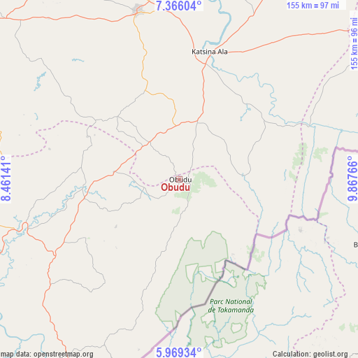
Obudu GPS coordinates[2]
6° 40' 5.484" North, 9° 9' 52.308" East
| Map corner | latitude | longitude |
|---|---|---|
| Upper-left | 7.36604°, | 8.46141° |
| Center: | 6.66819°, | 9.16453° |
| Lower-right: | 5.96934°, | 9.86766° |
| Map W x H: | 155.3×155.3 km | = 96.5×96.5mi |
| max Lat: | 13.7543° ⇑73.3% North |
| Obudu: | 6.66819° |
| min Lat: | ⇓26.7% South 4.31231° |
| min Long | Obudu | max Long |
| 2.73333° | 9.16453° | 14.46552° |
| W 78.1%⇐ | ⇒21.9% E |
Elevation
Elevation of Obudu is 224 m = 735 ft, and this is 72.5 m = 238 ft below average elevation for this country.
| Max E: |
1599 m = 5246 ft | 57.9% |
| Avg. | 296.5 m = 973 ft | |
| Obudu | 224 m = 735 ft | |
Min E: |
2 m = 7 ft | 42.1% |
See also: Nigeria elevation on elevation.city.
Geographical zone
Obudu is located in North Torrid zone (between Equator and Tropic of Cancer). Distance of Equator is 741.4 km =460.7 mi to South.| Distance of | km | miles | from Obudu |
|---|---|---|---|
| North Pole | 9265.6 | 5757.4 | to North |
| Arctic Circle | 6659.7 | 4138.1 | to North |
| Tropic Cancer | 1864.5 | 1158.5 | to North |
| Equator | 741.4 | 460.7 | to South |


Nearby cities:
15 places around Obudu: (largest is in red/bold)
• Abuochiche
24.6 km =15.3 mi,  276°
276°
• Adikpo
25.8 km =16 mi,  17°
17°
• Boje
50.5 km =31.4 mi,  212°
212°
• Buruku
88.1 km =54.7 mi,  2°
2°
• Gakem
22.2 km =13.8 mi,  300°
300°
• Gboko
75 km =46.6 mi,  346°
346°
• Katsina-Ala
57.3 km =35.6 mi,  13°
13°
• Lessel
53.5 km =33.2 mi,  342°
342°
• Ogoja
40.4 km =25.1 mi,  268°
268°
• Oju
84.6 km =52.6 mi, 283°
• Okpoma
58.8 km =36.5 mi,  262°
262°
• Sankwala
14.9 km =9.3 mi,  154°
154°
• Tse-Agberagba
71.4 km =44.4 mi,  309°
309°
• Vandeikya
16.8 km =10.4 mi,  320°
320°
• Yandev
78.4 km =48.7 mi, 350°
Sources, notices
• [Note1] Compared only with cities in Nigeria existing in our database
• [Src1] Map data: © OpenStreetMap contributors (CC-BY-SA)
• [Src2] Other city data from geonames.org with taken over terms of usage.
• [Src3] Geographical zone / Annual Mean Temperature by Robert A. Rohde @ Wikipedia
