Sankwala geodata
Sankwala (Cross River) is a seat of a second-order administrative division; located in Nigeria in Africa/Lagos (GMT+1) time zone. In our database, there are 451 cities with bigger population. Compared to other cities in Nigeria, 75.6% of cities are located further ↑North; 78.6% of cities are located further ←West and 52.2% of cities have lower elevation than Sankwala. Note1


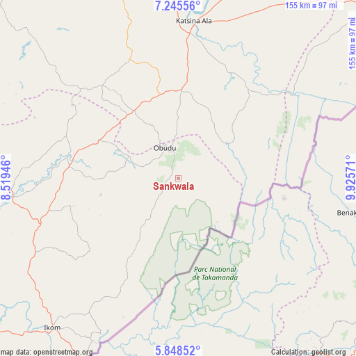
Sankwala GPS coordinates[2]
6° 32' 51.108" North, 9° 13' 21.288" East
| Map corner | latitude | longitude |
|---|---|---|
| Upper-left | 7.24556°, | 8.51946° |
| Center: | 6.54753°, | 9.22258° |
| Lower-right: | 5.84852°, | 9.92571° |
| Map W x H: | 155.3×155.3 km | = 96.5×96.5mi |
| max Lat: | 13.7543° ⇑75.6% North |
| Sankwala: | 6.54753° |
| min Lat: | ⇓24.4% South 4.31231° |
| min Long | Sankwala | max Long |
| 2.73333° | 9.22258° | 14.46552° |
| W 78.6%⇐ | ⇒21.4% E |
Elevation
Elevation of Sankwala is 295 m = 968 ft, and this is 1.5 m = 5 ft below average elevation for this country.
| Max E: |
1599 m = 5246 ft | 47.8% |
| Avg. | 296.5 m = 973 ft | |
| Sankwala | 295 m = 968 ft | |
Min E: |
2 m = 7 ft | 52.2% |
See also: Nigeria elevation on elevation.city.
Geographical zone
Sankwala is located in North Torrid zone (between Equator and Tropic of Cancer). Distance of Equator is 728 km =452.4 mi to South.| Distance of | km | miles | from Sankwala |
|---|---|---|---|
| North Pole | 9279 | 5765.7 | to North |
| Arctic Circle | 6673.2 | 4146.5 | to North |
| Tropic Cancer | 1877.9 | 1166.9 | to North |
| Equator | 728 | 452.4 | to South |


Nearby cities:
15 places around Sankwala: (largest is in red/bold)
• Abuochiche
34.7 km =21.6 mi,  297°
297°
• Adikpo
38.1 km =23.7 mi,  1°
1°
• Boje
44.4 km =27.6 mi,  228°
228°
• Effraya
94.4 km =58.7 mi,  215°
215°
• Gakem
35.5 km =22.1 mi,  314°
314°
• Gboko
89.6 km =55.7 mi,  344°
344°
• Ikom
86.2 km =53.6 mi, 221°
• Katsina-Ala
69.5 km =43.2 mi,  5°
5°
• Lessel
68.2 km =42.4 mi, 340°
• Obudu
14.9 km =9.3 mi,  334°
334°
• Ogoja
48.4 km =30.1 mi,  284°
284°
• Okpoma
64.9 km =40.3 mi,  274°
274°
• Tse-Agberagba
85.1 km =52.9 mi, 313°
• Vandeikya
31.4 km =19.5 mi, 327°
• Yandev
92.8 km =57.7 mi,  347°
347°
Sources, notices
• [Note1] Compared only with cities in Nigeria existing in our database
• [Src1] Map data: © OpenStreetMap contributors (CC-BY-SA)
• [Src2] Other city data from geonames.org with taken over terms of usage.
• [Src3] Geographical zone / Annual Mean Temperature by Robert A. Rohde @ Wikipedia
