Nkwerre geodata
Nkwerre (Imo) is a seat of a second-order administrative division; located in Nigeria in Africa/Lagos (GMT+1) time zone. With population of 62,973 people, there are 142 cities with bigger population in this country. Compared to other cities in Nigeria, 86.7% of cities are located further ↑North; 54% of cities are located further →East and 65% of cities have higher elevation than Nkwerre. Note1


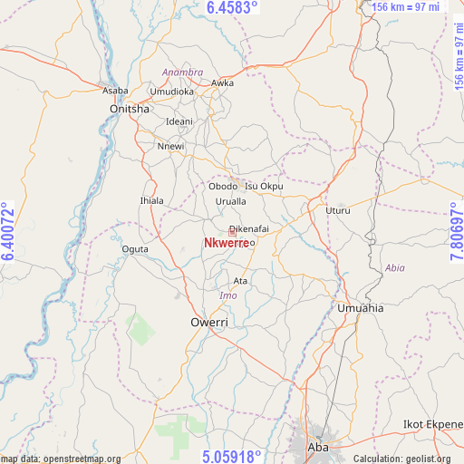
Nkwerre GPS coordinates[2]
5° 45' 33.012" North, 7° 6' 13.824" East
| Map corner | latitude | longitude |
|---|---|---|
| Upper-left | 6.4583°, | 6.40072° |
| Center: | 5.75917°, | 7.10384° |
| Lower-right: | 5.05918°, | 7.80697° |
| Map W x H: | 155.6×155.6 km | = 96.7×96.7mi |
| max Lat: | 13.7543° ⇑86.7% North |
| Nkwerre: | 5.75917° |
| min Lat: | ⇓13.3% South 4.31231° |
| min Long | Nkwerre | max Long |
| 2.73333° | 7.10384° | 14.46552° |
| W 46%⇐ | ⇒54% E |
Elevation
Elevation of Nkwerre is 179 m = 587 ft, and this is 117.5 m = 385 ft below average elevation for this country.
| Max E: |
1599 m = 5246 ft | 65% |
| Avg. | 296.5 m = 973 ft | |
| Nkwerre | 179 m = 587 ft | |
Min E: |
2 m = 7 ft | 35% |
See also: Nkwerre elevation on elevation.city.
Geographical zone
Nkwerre is located in North Torrid zone (between Equator and Tropic of Cancer). Distance of Equator is 640.4 km =397.9 mi to South.| Distance of | km | miles | from Nkwerre |
|---|---|---|---|
| North Pole | 9366.7 | 5820.2 | to North |
| Arctic Circle | 6760.8 | 4201 | to North |
| Tropic Cancer | 1965.6 | 1221.4 | to North |
| Equator | 640.4 | 397.9 | to South |


Nearby cities:
15 places around Nkwerre: (largest is in red/bold)
• Amaigbo
3.5 km =2.2 mi,  158°
158°
• Awo-Idemili
20.3 km =12.6 mi,  291°
291°
• Dikenafai
5.8 km =3.6 mi,  77°
77°
• Iho
19.7 km =12.2 mi,  181°
181°
• Mgbidi
24 km =14.9 mi,  262°
262°
• Nnenasa
10.4 km =6.5 mi,  253°
253°
• Nwaorieubi
22 km =13.7 mi,  206°
206°
• Okwe
12.8 km =8 mi, 80°
• Orlu
8.6 km =5.3 mi,  298°
298°
• Orodo
17.7 km =11 mi, 206°
• Uga
19.8 km =12.3 mi,  352°
352°
• Umuelemai
17.4 km =10.8 mi,  117°
117°
• Umumma
17.4 km =10.8 mi,  269°
269°
• Umundugba
9.9 km =6.2 mi,  200°
200°
• Urualla
10.6 km =6.6 mi,  357°
357°
Sources, notices
• [Note1] Compared only with cities in Nigeria existing in our database
• [Src1] Map data: © OpenStreetMap contributors (CC-BY-SA)
• [Src2] Other city data from geonames.org with taken over terms of usage.
• [Src3] Geographical zone / Annual Mean Temperature by Robert A. Rohde @ Wikipedia
