Urualla geodata
Urualla (Imo) is a seat of a second-order administrative division; located in Nigeria in Africa/Lagos (GMT+1) time zone. In our database, there are 451 cities with bigger population. Compared to other cities in Nigeria, 85.6% of cities are located further ↑North; 54.1% of cities are located further →East and 54.1% of cities have higher elevation than Urualla. Note1


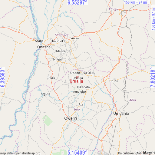
Urualla GPS coordinates[2]
5° 51' 14.292" North, 7° 5' 56.616" East
| Map corner | latitude | longitude |
|---|---|---|
| Upper-left | 6.55297°, | 6.39593° |
| Center: | 5.85397°, | 7.09906° |
| Lower-right: | 5.15409°, | 7.80218° |
| Map W x H: | 155.5×155.5 km | = 96.6×96.6mi |
| max Lat: | 13.7543° ⇑85.6% North |
| Urualla: | 5.85397° |
| min Lat: | ⇓14.4% South 4.31231° |
| min Long | Urualla | max Long |
| 2.73333° | 7.09906° | 14.46552° |
| W 45.9%⇐ | ⇒54.1% E |
Elevation
Elevation of Urualla is 252 m = 827 ft, and this is 44.5 m = 146 ft below average elevation for this country.
| Max E: |
1599 m = 5246 ft | 54.1% |
| Avg. | 296.5 m = 973 ft | |
| Urualla | 252 m = 827 ft | |
Min E: |
2 m = 7 ft | 45.9% |
See also: Nigeria elevation on elevation.city.
Geographical zone
Urualla is located in North Torrid zone (between Equator and Tropic of Cancer). Distance of Equator is 650.9 km =404.5 mi to South.| Distance of | km | miles | from Urualla |
|---|---|---|---|
| North Pole | 9356.2 | 5813.7 | to North |
| Arctic Circle | 6750.3 | 4194.4 | to North |
| Tropic Cancer | 1955 | 1214.8 | to North |
| Equator | 650.9 | 404.5 | to South |


Nearby cities:
15 places around Urualla: (largest is in red/bold)
• Aguata
18.1 km =11.2 mi,  356°
356°
• Ajalli
24.4 km =15.2 mi,  29°
29°
• Amaigbo
13.9 km =8.6 mi,  172°
172°
• Awo-Idemili
18.5 km =11.5 mi,  260°
260°
• Dikenafai
11.2 km =7 mi,  146°
146°
• Igbo-Ukwu
20.2 km =12.6 mi,  334°
334°
• Nkwerre
10.6 km =6.6 mi,  177°
177°
• Nnenasa
16.5 km =10.3 mi,  215°
215°
• Okwe
15.7 km =9.8 mi,  122°
122°
• Orlu
9.6 km =6 mi,  227°
227°
• Uga
9.4 km =5.8 mi,  346°
346°
• Ukpor
21.2 km =13.2 mi,  297°
297°
• Umumma
20.1 km =12.5 mi,  237°
237°
• Umundugba
20 km =12.4 mi,  188°
188°
• Umunze
19.7 km =12.2 mi,  50°
50°
Sources, notices
• [Note1] Compared only with cities in Nigeria existing in our database
• [Src1] Map data: © OpenStreetMap contributors (CC-BY-SA)
• [Src2] Other city data from geonames.org with taken over terms of usage.
• [Src3] Geographical zone / Annual Mean Temperature by Robert A. Rohde @ Wikipedia
