Uga geodata
Uga (Anambra) is a populated place; located in Nigeria in Africa/Lagos (GMT+1) time zone. With population of 64,179 people, there are 141 cities with bigger population in this country. Compared to other cities in Nigeria, 84.5% of cities are located further ↑North; 54.8% of cities are located further →East and 57.5% of cities have higher elevation than Uga. Note1


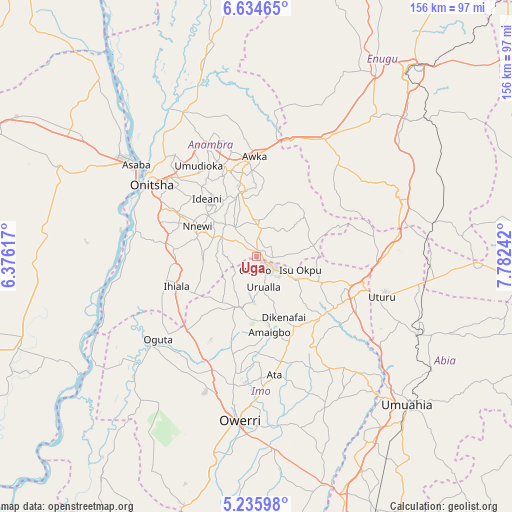
Uga GPS coordinates[2]
5° 56' 8.736" North, 7° 4' 45.48" East
| Map corner | latitude | longitude |
|---|---|---|
| Upper-left | 6.63465°, | 6.37617° |
| Center: | 5.93576°, | 7.0793° |
| Lower-right: | 5.23598°, | 7.78242° |
| Map W x H: | 155.5×155.5 km | = 96.6×96.6mi |
| max Lat: | 13.7543° ⇑84.5% North |
| Uga: | 5.93576° |
| min Lat: | ⇓15.5% South 4.31231° |
| min Long | Uga | max Long |
| 2.73333° | 7.0793° | 14.46552° |
| W 45.2%⇐ | ⇒54.8% E |
Elevation
Elevation of Uga is 227 m = 745 ft, and this is 69.5 m = 228 ft below average elevation for this country.
| Max E: |
1599 m = 5246 ft | 57.5% |
| Avg. | 296.5 m = 973 ft | |
| Uga | 227 m = 745 ft | |
Min E: |
2 m = 7 ft | 42.5% |
See also: Uga elevation on elevation.city.
Geographical zone
Uga is located in North Torrid zone (between Equator and Tropic of Cancer). Distance of Equator is 660 km =410.1 mi to South.| Distance of | km | miles | from Uga |
|---|---|---|---|
| North Pole | 9347.1 | 5808 | to North |
| Arctic Circle | 6741.2 | 4188.8 | to North |
| Tropic Cancer | 1945.9 | 1209.1 | to North |
| Equator | 660 | 410.1 | to South |


Nearby cities:
15 places around Uga: (largest is in red/bold)
• Aguata
9 km =5.6 mi,  6°
6°
• Agulu
18.4 km =11.4 mi,  353°
353°
• Ajalli
18.7 km =11.6 mi,  49°
49°
• Amaigbo
23.2 km =14.4 mi,  170°
170°
• Awo-Idemili
20.2 km =12.6 mi,  232°
232°
• Dikenafai
20.2 km =12.6 mi,  155°
155°
• Igbo-Ukwu
11.2 km =7 mi,  324°
324°
• Neni
18.7 km =11.6 mi,  341°
341°
• Nkwerre
19.8 km =12.3 mi, 172°
• Nnewi
20.2 km =12.6 mi,  297°
297°
• Okwe
23.3 km =14.5 mi,  138°
138°
• Orlu
16.3 km =10.1 mi,  197°
197°
• Ukpor
16.6 km =10.3 mi,  272°
272°
• Umunze
17.7 km =11 mi,  78°
78°
• Urualla
9.4 km =5.8 mi, 166°
Sources, notices
• [Note1] Compared only with cities in Nigeria existing in our database
• [Src1] Map data: © OpenStreetMap contributors (CC-BY-SA)
• [Src2] Other city data from geonames.org with taken over terms of usage.
• [Src3] Geographical zone / Annual Mean Temperature by Robert A. Rohde @ Wikipedia
