Orlu geodata
Orlu (Imo) is a seat of a second-order administrative division; located in Nigeria in Africa/Lagos (GMT+1) time zone. With population of 9,351 people, there are 347 cities with bigger population in this country. Compared to other cities in Nigeria, 86.2% of cities are located further ↑North; 55.6% of cities are located further →East and 65.6% of cities have higher elevation than Orlu. Note1


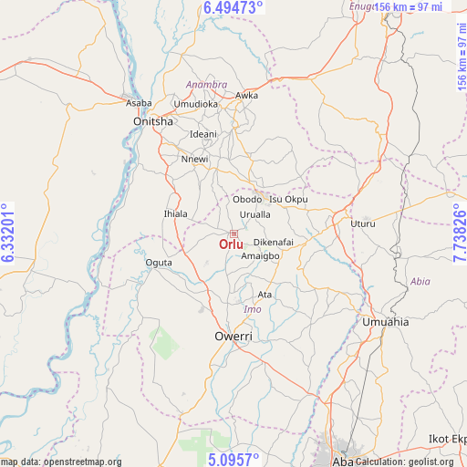
Orlu GPS coordinates[2]
5° 47' 44.34" North, 7° 2' 6.468" East
| Map corner | latitude | longitude |
|---|---|---|
| Upper-left | 6.49473°, | 6.33201° |
| Center: | 5.79565°, | 7.03513° |
| Lower-right: | 5.0957°, | 7.73826° |
| Map W x H: | 155.6×155.6 km | = 96.7×96.7mi |
| max Lat: | 13.7543° ⇑86.2% North |
| Orlu: | 5.79565° |
| min Lat: | ⇓13.8% South 4.31231° |
| min Long | Orlu | max Long |
| 2.73333° | 7.03513° | 14.46552° |
| W 44.4%⇐ | ⇒55.6% E |
Elevation
Elevation of Orlu is 173 m = 568 ft, and this is 123.5 m = 405 ft below average elevation for this country.
| Max E: |
1599 m = 5246 ft | 65.6% |
| Avg. | 296.5 m = 973 ft | |
| Orlu | 173 m = 568 ft | |
Min E: |
2 m = 7 ft | 34.4% |
See also: Nigeria elevation on elevation.city.
Geographical zone
Orlu is located in North Torrid zone (between Equator and Tropic of Cancer). Distance of Equator is 644.4 km =400.4 mi to South.| Distance of | km | miles | from Orlu |
|---|---|---|---|
| North Pole | 9362.6 | 5817.6 | to North |
| Arctic Circle | 6756.8 | 4198.5 | to North |
| Tropic Cancer | 1961.5 | 1218.8 | to North |
| Equator | 644.4 | 400.4 | to South |


Nearby cities:
15 places around Orlu: (largest is in red/bold)
• Amaigbo
11.5 km =7.1 mi,  129°
129°
• Awo-Idemili
11.7 km =7.3 mi,  286°
286°
• Dikenafai
13.5 km =8.4 mi,  102°
102°
• Ihiala
20.5 km =12.7 mi, 288°
• Mgbidi
17.7 km =11 mi,  246°
246°
• Nkwerre
8.6 km =5.3 mi,  118°
118°
• Nnenasa
7.4 km =4.6 mi,  198°
198°
• Nwaorieubi
23.9 km =14.9 mi,  184°
184°
• Okwe
20.3 km =12.6 mi, 95°
• Orodo
19.9 km =12.4 mi, 180°
• Uga
16.3 km =10.1 mi,  17°
17°
• Ukpor
20.1 km =12.5 mi,  324°
324°
• Umumma
10.7 km =6.6 mi, 246°
• Umundugba
13.9 km =8.6 mi,  163°
163°
• Urualla
9.6 km =6 mi,  47°
47°
Sources, notices
• [Note1] Compared only with cities in Nigeria existing in our database
• [Src1] Map data: © OpenStreetMap contributors (CC-BY-SA)
• [Src2] Other city data from geonames.org with taken over terms of usage.
• [Src3] Geographical zone / Annual Mean Temperature by Robert A. Rohde @ Wikipedia
