Iho geodata
Iho (Imo) is a seat of a second-order administrative division; located in Nigeria in Africa/Lagos (GMT+1) time zone. With population of 7,776 people, there are 390 cities with bigger population in this country. Compared to other cities in Nigeria, 88.7% of cities are located further ↑North; 54.3% of cities are located further →East and 69.7% of cities have higher elevation than Iho. Note1


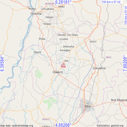
Iho GPS coordinates[2]
5° 34' 56.1" North, 7° 5' 56.256" East
| Map corner | latitude | longitude |
|---|---|---|
| Upper-left | 6.28161°, | 6.39584° |
| Center: | 5.58225°, | 7.09896° |
| Lower-right: | 4.88206°, | 7.80209° |
| Map W x H: | 155.6×155.6 km | = 96.7×96.7mi |
| max Lat: | 13.7543° ⇑88.7% North |
| Iho: | 5.58225° |
| min Lat: | ⇓11.3% South 4.31231° |
| min Long | Iho | max Long |
| 2.73333° | 7.09896° | 14.46552° |
| W 45.7%⇐ | ⇒54.3% E |
Elevation
Elevation of Iho is 149 m = 489 ft, and this is 147.5 m = 484 ft below average elevation for this country.
| Max E: |
1599 m = 5246 ft | 69.7% |
| Avg. | 296.5 m = 973 ft | |
| Iho | 149 m = 489 ft | |
Min E: |
2 m = 7 ft | 30.3% |
See also: Nigeria elevation on elevation.city.
Geographical zone
Iho is located in North Torrid zone (between Equator and Tropic of Cancer). Distance of Equator is 620.7 km =385.7 mi to South.| Distance of | km | miles | from Iho |
|---|---|---|---|
| North Pole | 9386.4 | 5832.4 | to North |
| Arctic Circle | 6780.5 | 4213.2 | to North |
| Tropic Cancer | 1985.2 | 1233.5 | to North |
| Equator | 620.7 | 385.7 | to South |


Nearby cities:
15 places around Iho: (largest is in red/bold)
• Aboh
22.5 km =14 mi,  121°
121°
• Afor-Oru
19.3 km =12 mi,  103°
103°
• Amaigbo
16.5 km =10.3 mi,  6°
6°
• Dikenafai
21.8 km =13.5 mi,  16°
16°
• Nkwerre
19.7 km =12.2 mi,  1°
1°
• Nnenasa
19.2 km =11.9 mi,  330°
330°
• Nwaorieubi
9.1 km =5.7 mi,  269°
269°
• Okwe
25.4 km =15.8 mi,  31°
31°
• Orlu
24.8 km =15.4 mi,  343°
343°
• Orodo
8.2 km =5.1 mi,  297°
297°
• Owerri
13.2 km =8.2 mi,  213°
213°
• Umuelemai
19.8 km =12.3 mi,  53°
53°
• Umuguma
19.5 km =12.1 mi,  229°
229°
• Umumma
25.7 km =16 mi,  318°
318°
• Umundugba
10.8 km =6.7 mi, 343°
Sources, notices
• [Note1] Compared only with cities in Nigeria existing in our database
• [Src1] Map data: © OpenStreetMap contributors (CC-BY-SA)
• [Src2] Other city data from geonames.org with taken over terms of usage.
• [Src3] Geographical zone / Annual Mean Temperature by Robert A. Rohde @ Wikipedia
