Nasarawa geodata
Nasarawa (Nassarawa) is a seat of a second-order administrative division; located in Nigeria in Africa/Lagos (GMT+1) time zone. With population of 30,949 people, there are 162 cities with bigger population in this country. Compared to other cities in Nigeria, 51.3% of cities are located further ↓South; 57.8% of cities are located further ←West and 63.6% of cities have higher elevation than Nasarawa. Note1


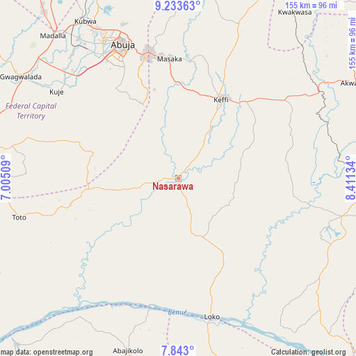
Nasarawa GPS coordinates[2]
8° 32' 20.22" North, 7° 42' 29.556" East
| Map corner | latitude | longitude |
|---|---|---|
| Upper-left | 9.23363°, | 7.00509° |
| Center: | 8.53895°, | 7.70821° |
| Lower-right: | 7.843°, | 8.41134° |
| Map W x H: | 154.6×154.6 km | = 96.1×96.1mi |
| max Lat: | 13.7543° ⇑48.7% North |
| Nasarawa: | 8.53895° |
| min Lat: | ⇓51.3% South 4.31231° |
| min Long | Nasarawa | max Long |
| 2.73333° | 7.70821° | 14.46552° |
| W 57.8%⇐ | ⇒42.2% E |
Elevation
Elevation of Nasarawa is 185 m = 607 ft, and this is 111.5 m = 366 ft below average elevation for this country.
| Max E: |
1599 m = 5246 ft | 63.6% |
| Avg. | 296.5 m = 973 ft | |
| Nasarawa | 185 m = 607 ft | |
Min E: |
2 m = 7 ft | 36.4% |
See also: Nigeria elevation on elevation.city.
Geographical zone
Nasarawa is located in North Torrid zone (between Equator and Tropic of Cancer). Distance of Equator is 949.4 km =589.9 mi to South.| Distance of | km | miles | from Nasarawa |
|---|---|---|---|
| North Pole | 9057.6 | 5628.1 | to North |
| Arctic Circle | 6451.7 | 4008.9 | to North |
| Tropic Cancer | 1656.5 | 1029.3 | to North |
| Equator | 949.4 | 589.9 | to South |


Nearby cities:
15 places around Nasarawa: (largest is in red/bold)
• Abaji
84.3 km =52.4 mi,  265°
265°
• Abejukolo
77.7 km =48.3 mi,  196°
196°
• Abuja
62.3 km =38.7 mi,  337°
337°
• Buga
40.7 km =25.3 mi,  262°
262°
• Bugana
61.6 km =38.3 mi,  192°
192°
• Doma
73 km =45.4 mi,  102°
102°
• Garaku
57.7 km =35.9 mi,  53°
53°
• Gwagwalada
82.2 km =51.1 mi,  303°
303°
• Karu
52.6 km =32.7 mi,  354°
354°
• Keffi
38.7 km =24 mi,  27°
27°
• Kuje
65 km =40.4 mi,  305°
305°
• Kwali
84.9 km =52.8 mi, 296°
• Madala
83.1 km =51.6 mi,  319°
319°
• Obagaji
75.3 km =46.8 mi,  162°
162°
• Toto
71.4 km =44.4 mi, 256°
Sources, notices
• [Note1] Compared only with cities in Nigeria existing in our database
• [Src1] Map data: © OpenStreetMap contributors (CC-BY-SA)
• [Src2] Other city data from geonames.org with taken over terms of usage.
• [Src3] Geographical zone / Annual Mean Temperature by Robert A. Rohde @ Wikipedia
