Kuje geodata
Kuje (FCT) is a seat of a second-order administrative division; located in Nigeria in Africa/Lagos (GMT+1) time zone. With population of 97,367 people, there are 88 cities with bigger population in this country. Compared to other cities in Nigeria, 53.7% of cities are located further ↓South; 52% of cities are located further →East and 53.6% of cities have lower elevation than Kuje. Note1


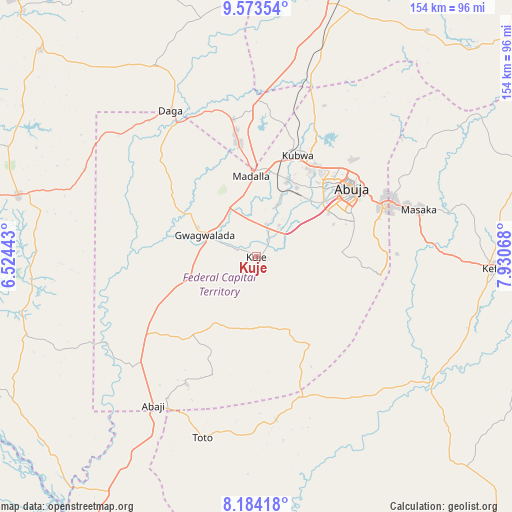
Kuje GPS coordinates[2]
8° 52' 46.272" North, 7° 13' 39.216" East
| Map corner | latitude | longitude |
|---|---|---|
| Upper-left | 9.57354°, | 6.52443° |
| Center: | 8.87952°, | 7.22756° |
| Lower-right: | 8.18418°, | 7.93068° |
| Map W x H: | 154.5×154.5 km | = 96×96mi |
| max Lat: | 13.7543° ⇑46.3% North |
| Kuje: | 8.87952° |
| min Lat: | ⇓53.7% South 4.31231° |
| min Long | Kuje | max Long |
| 2.73333° | 7.22756° | 14.46552° |
| W 48%⇐ | ⇒52% E |
Elevation
Elevation of Kuje is 300 m = 984 ft, and this is 3.5 m = 11 ft above average elevation for this country.
| Max E: |
1599 m = 5246 ft | 46.4% |
| Kuje | 300 m 984 ft | |
| Avg. | 296.5 m = 973 ft | |
Min E: |
2 m = 7 ft | 53.6% |
See also: Kuje elevation on elevation.city.
Geographical zone
Kuje is located in North Torrid zone (between Equator and Tropic of Cancer). Distance of Equator is 987.3 km =613.5 mi to South.| Distance of | km | miles | from Kuje |
|---|---|---|---|
| North Pole | 9019.8 | 5604.6 | to North |
| Arctic Circle | 6413.9 | 3985.4 | to North |
| Tropic Cancer | 1618.6 | 1005.8 | to North |
| Equator | 987.3 | 613.5 | to South |


Nearby cities:
15 places around Kuje: (largest is in red/bold)
• Abaji
54.8 km =34.1 mi,  214°
214°
• Abuja
35.4 km =22 mi,  55°
55°
• Buga
45 km =28 mi,  163°
163°
• Bwari
47.6 km =29.6 mi,  20°
20°
• Gawu Babangida
51.3 km =31.9 mi,  329°
329°
• Gwagwalada
17.5 km =10.9 mi,  293°
293°
• Karu
49.8 km =30.9 mi,  73°
73°
• Keffi
71.1 km =44.2 mi,  92°
92°
• Kwali
23 km =14.3 mi,  271°
271°
• Lapai
74.4 km =46.2 mi,  284°
284°
• Madala
25.1 km =15.6 mi,  356°
356°
• Nasarawa
65 km =40.4 mi,  125°
125°
• Sabon Wuse
50.7 km =31.5 mi,  4°
4°
• Suleja
33.9 km =21.1 mi,  351°
351°
• Toto
57.1 km =35.5 mi,  196°
196°
Sources, notices
• [Note1] Compared only with cities in Nigeria existing in our database
• [Src1] Map data: © OpenStreetMap contributors (CC-BY-SA)
• [Src2] Other city data from geonames.org with taken over terms of usage.
• [Src3] Geographical zone / Annual Mean Temperature by Robert A. Rohde @ Wikipedia
