Bugana geodata
Bugana (Kogi) is a populated place; located in Nigeria in Africa/Lagos (GMT+1) time zone. With population of 9,737 people, there are 339 cities with bigger population in this country. Compared to other cities in Nigeria, 53% of cities are located further ↑North; 55.2% of cities are located further ←West and 78.9% of cities have higher elevation than Bugana. Note1


Bugana GPS coordinates[2]
7° 59' 57.012" North, 7° 35' 0.996" East
| Map corner | latitude | longitude |
|---|---|---|
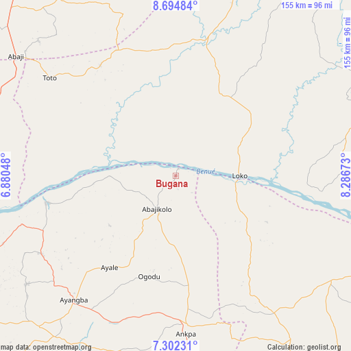
| Upper-left | 8.69484°, | 6.88048° |
| Center: | 7.99917°, | 7.58361° |
| Lower-right: | 7.30231°, | 8.28673° |
| Map W x H: | 154.8×154.8 km | = 96.2×96.2mi |
| max Lat: | 13.7543° ⇑53% North |
| Bugana: | 7.99917° |
| min Lat: | ⇓47% South 4.31231° |
| min Long | Bugana | max Long |
| 2.73333° | 7.58361° | 14.46552° |
| W 55.2%⇐ | ⇒44.8% E |
Elevation
Elevation of Bugana is 89 m = 292 ft, and this is 207.5 m = 681 ft below average elevation for this country.
| Max E: |
1599 m = 5246 ft | 78.9% |
| Avg. | 296.5 m = 973 ft | |
| Bugana | 89 m = 292 ft | |
Min E: |
2 m = 7 ft | 21.1% |
See also: Nigeria elevation on elevation.city.
Geographical zone
Bugana is located in North Torrid zone (between Equator and Tropic of Cancer). Distance of Equator is 889.4 km =552.6 mi to South.| Distance of | km | miles | from Bugana |
|---|---|---|---|
| North Pole | 9117.6 | 5665.4 | to North |
| Arctic Circle | 6511.7 | 4046.2 | to North |
| Tropic Cancer | 1716.5 | 1066.6 | to North |
| Equator | 889.4 | 552.6 | to South |


Nearby cities:
15 places around Bugana: (largest is in red/bold)
• Abaji
87.9 km =54.6 mi,  306°
306°
• Abejukolo
16.7 km =10.4 mi,  209°
209°
• Abocho
81.4 km =50.6 mi,  233°
233°
• Ankpa
66.6 km =41.4 mi,  175°
175°
• Boju
79.3 km =49.3 mi,  154°
154°
• Buga
60.8 km =37.8 mi,  333°
333°
• Dekina
68.7 km =42.7 mi,  239°
239°
• Koton-Karfe
87.1 km =54.1 mi,  276°
276°
• Naka
82.6 km =51.3 mi,  124°
124°
• Nasarawa
61.6 km =38.3 mi,  12°
12°
• Obagaji
37.8 km =23.5 mi,  108°
108°
• Oguma
58.5 km =36.4 mi,  258°
258°
• Okpo
87.1 km =54.1 mi, 181°
• Toto
70.5 km =43.8 mi, 307°
• Ugbokpo
50.7 km =31.5 mi,  139°
139°
Sources, notices
• [Note1] Compared only with cities in Nigeria existing in our database
• [Src1] Map data: © OpenStreetMap contributors (CC-BY-SA)
• [Src2] Other city data from geonames.org with taken over terms of usage.
• [Src3] Geographical zone / Annual Mean Temperature by Robert A. Rohde @ Wikipedia
